Other ID: WHOI Pea Island Walking Surveys and Bathymetry 2020-2021
Status: Pending
Organization(s): USGS, Woods Hole Coastal and Marine Science Center
Funding Program(s): Other (Other)
Data Source Information: Woods Hole Oceanographic Institution - Peter Traykovski
Information Specialist(s): Jin-Si Over
Data Type(s): Location-Elevation: Navigation, Sonar: Single Beam
Start Date: 2020-11-22
End Date: 2021-04-20
Equipment Used: PPK GPS, Real Time Kinematic GPS, Echosounder ECS 24D
Information to be Derived: Bathymetry, topography.
Summary of Activity and Data Gathered: Peter Traykovski (WHOI) collected five days of data: 2020-11-22, 2020-11-25, 2020-11-27, 2021-04-19, 2021-04-20. Small surf vehicle was used to collect bathymetry up to 15 m. Backpack walking surveys with continuous GPS successfully mapped the beach. Data collected happened to be in the same location as the DUNEX experiment completed in in 2021 (see 2021-028-FA and 2021-029-FA) and was donated to the USGS as a way to have a longer time series on the field site topobathy at Pea Island. Bathymetry and topography also collected at the southwest section of the Basnight Bridge where it is eroding to see if that would be a feasible study site for DUNEX change during a storm.
Notes: Data is for a pre-survey of the Pea Island DUNEX site (2021-029-FA, 2021-028-FA) and takes place in the same location. Data donated by Peter Traykovski of WHOI
Location:
Pea Island National Wildlife Refuge, Dare County, NC
| Boundaries | |||
|---|---|---|---|
| North: 35.7668646 | South: 35.67366929 | West: -75.52712631 | East: -75.46330262 |
Platform(s):
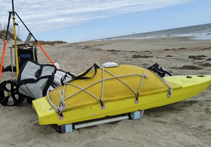 WHOI SSV |  on foot |
| Survey Equipment | Survey Info | Data Type(s) | Data Collected |
|---|---|---|---|
| PPK GPS | PPK was used to by Peter Traykovski of WHOI for a walking survey and as GPS on the Autonomous surface vehicles. | Navigation | |
| Real Time Kinematic GPS | --- | Navigation | Back-pack GPS Measurements (A JAVAD Triumph-2 GNSS receiver (https://www.agt-dz.com/en/shop/product/javad-triumph-2-gnss-receiver-594?category=7#attr=) was used to collect elevation data relative to a base station. Raw data is XYZ information as a txt file and data points are interpolated to create a low resolution DEM.) |
| Echosounder ECS 24D | --- | Single Beam | Pea Island Bathymetry, pre-DUNEX (Attached to SSV-Small Surface Vessel, Echologger ECS D24 used to collect bathymetry data on Pea Island National Seashore) |
