AKA: ERO20 bathy survey
Other ID: none
Status: Cancelled
Organization(s): USGS, Pacific Coastal and Marine Science Center
Funding Program(s): Sediment Transport in Coastal Environments (ZP00FDB)
Principal Investigator(s): Jessica Lacy
Affiliate Investigator(s):
Information Specialist(s): Andrew Stevens
Data Type(s): Sonar: Single Beam
Scientific Purpose/Goals: Perform bathymetric survey at two sites in northern San Francisco bay
Vehicle(s): MarFac; crewcab - G63-2147R
Start Port/Location: Benicia, CA
End Port/Location: Benicia, CA
Start Date: 2020-09-09
End Date: 2020-09-09
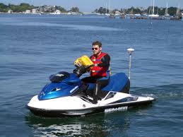
Equipment Used: Waverunners
Information to be Derived: Bathymetry
Summary of Activity and Data Gathered: Activity was not able to be conducted due to poor air quality and was cancelled.
Staff: Jackson Currie
Affiliate Staff:
Notes:
Location:
Northern San Francisco Bay
| Boundaries | |||
|---|---|---|---|
| North: 38.20192861 | South: 37.86271151 | West: -122.61728843 | East: -121.79774707 |
Platform(s):
 Waverunner 1 (SC) |  Waverunner 2 (SC) |
| Survey Equipment | Survey Info | Data Type(s) | Data Collected |
|---|---|---|---|
| Waverunners | --- | Navigation Single Beam |