Other ID: none
Status: Completed
Organization(s): USGS, Woods Hole Coastal and Marine Science Center
Funding Program(s): Other (Other)
Principal Investigator(s): David Foster
Affiliate Investigator(s): Jennifer Miselis
Information Specialist(s): Seth Ackerman
Data Type(s): Sonar: Sound Velocity, Seismics: Sub Bottom Profiler, Sonar: Multibeam
Scientific Purpose/Goals: To determine the morphology and seismic stratigraphy of the nearshore bars and shoreface of eastern Cape Cod for the purpose of understanding seal and Great White Shark behavior in this environment.
Vehicle(s):
Start Port/Location: Chatham, Massachusetts
End Port/Location: Chatham, Massachusetts
Start Date: 2021-06-09
End Date: 2021-06-25
Equipment Used: AML Minos X, EdgeTech 424 chirp sub-bottom profiler, Reson T20-P
Information to be Derived: Bathymetry, backscatter, sand shoal thickness
Summary of Activity and Data Gathered: The primary objective for this project successfully completed 100 percent bathymetric and acoustic backscatter coverage that includes the outer bar and as much of the trough and shoreface as possible for a 10 km stretch from Coast Guard Beach to north of Marconi Beach. Acquire subbottom data that images the thickness of modern sand shoals and characteristics of the underlying glacial drift. Due to survey time constraints, we did not completely cover the full offshore range of the 2018 lidar data. The secondary objective partially completed 100 percent bathymetric and acoustic backscatter for a 3 km stretch along Nauset Beach, Nauset Heights and Callanan's Pass. We were able to collect subbottom profiles that image modern sand shoals and underlying glacial deposits. With more survey time at high tide, we could have could have acquired more data close to shore in this area. We tested the Reson T20P dual head mutibeam sonar and the Edgetech 424 chirp subottom systems on June 9, 2021 along Nauset Beach. The data acquired were very good quality and are included with the data collected from June 15 to June 24, 2021.
Staff: Seth Ackerman, David Foster, Alexander Nichols, Charles Worley
Affiliate Staff:
Notes: Entries for this field activity are based on entries from Field Activity 2020-002-FA.
Rescheduling of the 2020 field activity.
Location:
Cape Cod, Massachusetts, United States, Atlantic Ocean
| Boundaries | |||
|---|---|---|---|
| North: 41.95069985 | South: 41.78012665 | West: -69.98688286 | East: -69.91022382 |
Platform(s):
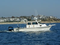
 Rafael |
Ackerman, S.D., Foster, D.S., Worley, C.R., and Nichols, A.R., 2022, High-resolution geophysical and geological data collected from outer Cape Cod, Massachusetts during USGS Field Activity 2021-004-FA: U.S. Geological Survey data release, https://doi.org/10.5066/P9GO90TI.
Sherwood, C.R., Aretxabaleta, A.L., Traykovski, P.A., Over, J.R., Lyons, E.O., Foster, D.S., Miselis, J.L., Nelson, T.R., Sogut, E., 2023, Contributions to uncertainty in runup forecasts: , Proceedings of Coastal Sediment 2023. doi: 10.1142/9789811275135_0037.
Sherwood, C.R., Foster, D.S., Miselis, J.L., Over, J.R., Marsjanik, E.D., Traykovski, P., 2022, Variability of Cape Cod Bars: Changes over Space and Time: , Cape Cod National Seashore 2022 Science in the Seashore Symposium.
| Survey Equipment | Survey Info | Data Type(s) | Data Collected |
|---|---|---|---|
| AML Minos X | --- | Sound Velocity | 2021-004-FA_SVP_data (RAW sound velocity profile data from a Minos X collected from outer Cape Cod, Massachusetts during USGS Field Activity 2021-004-FA (PNG images, SVP text, and point shapefile, GCS WGS 84)) |
| EdgeTech 424 chirp sub-bottom profiler | --- | Sub Bottom Profiler | 2021-004-FA_SB424 (Chirp seismic reflection - shotpoints, tracklines, profile images, and SEG-Y traces for EdgeTech SB-424 chirp data collected during USGS field activity 2021-004-FA (point and polyline shapefiles, CSV text, PNG Images, and SEGY data, GCS WGS 84)) |
| Reson T20-P | --- | Multibeam Water column reflectivity | 2021-004-FA_T20P_Backscatter_1m (Multibeam backscatter data collected during USGS Field Activity 2021-004-FA, using a dual-head Teledyne SeaBat T20-P multibeam echo sounder (8-bit GeoTIFF, UTM Zone 19N, WGS84, 1-m resolution)) 2021-004-FA_T20P_Bathymetry_2m_NAVD88 (Multibeam bathymetric data collected during USGS field activity 2021-004-FA, using a dual-head Teledyne SeaBat T20-P multibeam echo sounder (32-bit GeoTIFF, UTM Zone 19N, NAD 83, NAVD88 Vertical Datum, 2-m resolution)) 2021-004-FA_T20P_Tracklines (Multibeam sonar tracklines collected during USGS field activity 2021-004-FA, using a dual-head Teledyne SeaBat T20-P multibeam echo sounder (Esri polyline shapefile, GCS WGS 84)) |