AKA: 2021 Skagit Eelgrass survey
Other ID: none
Status: Completed
Organization(s): USGS, Pacific Coastal and Marine Science Center
Funding Program(s): Other (Other)
Principal Investigator(s): Eric Grossman
Affiliate Investigator(s):
Information Specialist(s): Nathan vanArendonk, Andrew Stevens
Data Type(s): Sonar: Single Beam, Location-Elevation: Transects
Scientific Purpose/Goals: Collect bathymetry and eelgrass distribution data on the Skagit River delta
Vehicle(s): None
Start Port/Location: La Conner, WA
End Port/Location: La Conner, WA
Start Date: 2021-03-08
End Date: 2021-03-12
Equipment Used: Trimble R7 GPS (AS), Biosonics 420kHz
Information to be Derived: Bathymetry and eelgrass distributions
Summary of Activity and Data Gathered: Collected bathymetry and eelgrass distributions across the Skagit River delta
Staff: Nathan vanArendonk
Affiliate Staff:
Notes: Vessel is Washington State Department of Ecology research vessel George Davidson
Location:
Puget Sound
| Boundaries | |||
|---|---|---|---|
| North: 48.44232052 | South: 48.20344234 | West: -122.60959249 | East: -122.30310448 |
Platform(s):
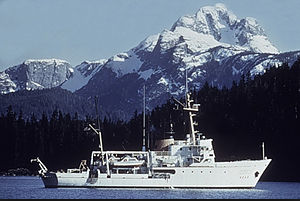 George Davidson |
| Survey Equipment | Survey Info | Data Type(s) | Data Collected |
|---|---|---|---|
| Trimble R7 GPS (AS) | --- | Benchmarks Navigation Profiles Transects | |
| Biosonics 420kHz | --- | Single Beam |
