Other ID: Sediment Trap Cruise
Status: Completed
Organization(s): USGS, St. Petersburg Coastal and Marine Science Center
Funding Program(s): Climate and Land Use Research and Development (GX.21.MN00.E8Z52.00)
Principal Investigator(s): Caitlin Reynolds
Affiliate Investigator(s):
Information Specialist(s):
Data Type(s): Sampling: Geology
Scientific Purpose/Goals: To collect and redeploy sediment trap mooring.
Vehicle(s): None
Start Port/Location: Saint Petersburg, FL
End Port/Location: Pensacola, FL
Start Date: 2022-05-14
End Date: 2022-05-17
Equipment Used: Sediment Trap
Information to be Derived: sediment trap samples (foraminifera assemblage and flux data) CTD cast (pH, fluorescence, salinity, temperature, oxygen)
Summary of Activity and Data Gathered: Collect 2 sediment traps on the mooring, 21 cup trap and 13 cup trap
Staff:
Affiliate Staff:
Notes:
Location:
Northern Gulf of America (Gulf of Mexico)
| Boundaries | |||
|---|---|---|---|
| North: 28.250117 | South: 28.230117 | West: -89.137993 | East: -89.117993 |
Platform(s):
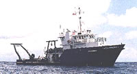 Weatherbird II |
| Survey Equipment | Survey Info | Data Type(s) | Data Collected |
|---|---|---|---|
| Sediment Trap | --- | Geology |
