AKA: none
Other ID: Elwha 2022 summer survey
Status: Completed
Organization(s): USGS, Pacific Coastal and Marine Science Center
Funding Program(s): Landscape Response to Disturbance (ZP00TJV)
Principal Investigator(s): Jonathan Warrick
Affiliate Investigator(s):
Information Specialist(s): Andrew Stevens
Data Type(s): Sampling: Geology, Sonar: Sound Velocity, Sonar: Single Beam, Location-Elevation: Transects, Location-Elevation: Navigation
Scientific Purpose/Goals: Collect nearshore bathymetry and beach topography on the Elwha River delta
Vehicle(s): MarFac; Expedition G62-3094P
Start Port/Location: Port Angeles, WA
End Port/Location: Port Angeles, WA
Start Date: 2022-08-08
End Date: 2022-08-12
Equipment Used: Hand-grab sample, YSI Sound velocity CTD, Waverunners, Waverunners, Trimble R7 GPS receiver 9, Trimble R7 GPS receiver, Trimble R7 GPS (AS), Trimble R7 GPS receiver 9, Trimble R7 GPS receiver, Trimble R7 GPS (AS)
Information to be Derived: Nearshore Bathymetry, Beach Topography
Summary of Activity and Data Gathered: Bathymetry and beach topography data collected, and data are archived on FAD.
Staff: Jonathan Warrick, Andrew Stevens, Andrew Ritchie, Cordell Johnson, Jackson Currie
Affiliate Staff:
Notes: Entries for this field activity are based on entries from Field Activity 2020-623-FA
Entries for this field activity are based on entries from Field Activity 2021-640-FA
Location:
Puget Sound
| Boundaries | |||
|---|---|---|---|
| North: 48.17624572 | South: 48.10493829 | West: -123.633 | East: -123.38360665 |
Platform(s):
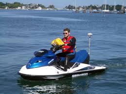
 Waverunner 1 (SC) |  Waverunner 2 (SC) |
Stevens, A.W., Gelfenbaum, G.R., Warrick, J.A., Miller, I.M., and Weiner, H.M., 2023, Bathymetry, topography, and sediment grainsize data from the Elwha River delta, Washington, August 2022: U.S. Geological Survey data release, https://doi.org/10.5066/P9N7N9P0.
| Survey Equipment | Survey Info | Data Type(s) | Data Collected |
|---|---|---|---|
| Hand-grab sample | --- | Biology Chemistry Geology | Surface-sediment grain-size distributions of the Elwha River delta, Washington, August 2022 (This portion of the data release presents sediment grain-size data from samples collected on the Elwha River delta, Washington, in August 2022 (USGS Field Activity 2022-638-FA). Surface sediment was collected from 67 locations using a small ponar, or 'grab', sampler from the R/V Frontier in water depths between about 1 and 17 m around the delta. An additional 44 samples were collected by hand at low tide. A hand-held global satellite navigation system (GNSS) receiver was used to determine the locations of sediment samples. The grain size distributions of suitable samples were determined using standard techniques developed by the USGS Pacific Coastal and Marine Science Center sediment lab. Grab samples that yielded less than 50 g of sediment were omitted from analysis. The grain-size data are provided in a comma-delimited spreadsheet (.csv).) |
| YSI Sound velocity CTD | --- | CTD Sound Velocity | |
| Waverunners | --- | Navigation Single Beam | |
| Waverunners | --- | Navigation Single Beam | Nearshore bathymetry data from the Elwha River delta, Washington, August 2022 (This portion of the USGS data release presents bathymetric data collected during surveys performed on the Elwha River delta, Washington in 2022 (USGS Field Activity Number 2022-638-FA). Bathymetric data were collected using personal watercraft (PWCs) and a kayak equipped with single-beam sonar systems and global navigation satellite system (GNSS) receivers.) |
| Trimble R7 GPS receiver 9 | --- | Benchmarks LIDAR Navigation Profiles Transects | |
| Trimble R7 GPS receiver | --- | Benchmarks LIDAR Navigation Profiles Transects | Topography data from the Elwha River delta, Washington, August 2022 (This part of the data release presents topography data from the Elwha River delta collected in August 2022. Topography data were collected on foot with global navigation satellite system (GNSS) receivers mounted on backpacks.) |
| Trimble R7 GPS (AS) | --- | Benchmarks Navigation Profiles Transects | |
| Trimble R7 GPS receiver 9 | --- | Benchmarks LIDAR Navigation Profiles Transects | |
| Trimble R7 GPS receiver | --- | Benchmarks LIDAR Navigation Profiles Transects | |
| Trimble R7 GPS (AS) | --- | Benchmarks Navigation Profiles Transects |