Other ID: MGL2306; Neogene Atlantic MTDs
Status: Completed
Organization(s): USGS, Woods Hole Coastal and Marine Science Center
Funding Program(s): Marine Geohazards Sources and Probability (LQ00ENR)
Principal Investigator(s): Nathaniel Miller
Affiliate Investigator(s):
Information Specialist(s): Wayne Baldwin
Data Type(s): Location-Elevation: Navigation, Seismics: Air Gun / Water Gun, Sonar: Water column reflectivity, Sonar: Multibeam, Seismics: Sub Bottom Profiler, Seismics: Multichannel
Scientific Purpose/Goals: Determine Neogene history of submarine landslide activity offshore North Carolina
Vehicle(s):
Start Port/Location: Norfolk, VA
End Port/Location: Jacksonville, FL
Start Date: 2023-05-07
End Date: 2023-06-13
Equipment Used: DGPS, Air gun, Knudsen 3260, Multichannel seismics, EM122 12 kHz multibeam, Simrad EK80, POS-MV
Information to be Derived: Images of buried mass transport deposits
Summary of Activity and Data Gathered: Collected 3,544-line kilometers of multichannel seismic reflection profiles, 4,430-line kilometers of Knudsen 3260 Chirp sub-bottom profiles, 4,340 line-kilometers of Kongsberg EM122 MBES bathymetry, as well as underway navigation, gravity, magnetics, ADCP, and XBT data during 26 days of survey.
Staff: William Danforth, David Foster
Affiliate Staff:
Notes:
Location:
US Atlantic Margin
| Boundaries | |||
|---|---|---|---|
| North: 36.45663601 | South: 27.83907609 | West: -78.22265625 | East: -68.37890625 |
Platform(s):
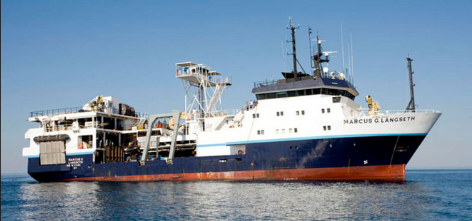 Marcus G. Langseth |
Baldwin, W., Miller, N.C., Ruppel, C., Becel, A., Daigle, H., Gibson, J., Grall, C.J., 2024, Multiple Bottom-Simulating Reflections as Evidence for Gas-Hydrate System Response to Geologic and Oceanographic Controls: New Insights from the U.S. Atlantic Margin: , AGU Fall Meeting 2024. URL: https://agu.confex.com/agu/agu24/meetingapp.cgi/Paper/1590668.
Ruppel, C., Baldwin, W., Miller, N.C., 2024, Modeling constraints on geologic, oceanographic, and climate change processes responsible for multiple generations of bottom simulating reflections observed on the U.S. Atlantic Margin: , AGU Fall Meeting 2024. URL: https://agu.confex.com/agu/agu24/meetingapp.cgi/Paper/1554172.
| Survey Equipment | Survey Info | Data Type(s) | Data Collected |
|---|---|---|---|
| DGPS | --- | Navigation | |
| Air gun | 18-element, 3300 cu.in air gun array configured in two parallel 9-gun strings. | Air Gun / Water Gun | |
| Knudsen 3260 | KEL 3260 configured with a four-by-four, array of sixteen 3.5 kHz Massa TR-1075 transducers. | Sub Bottom Profiler | |
| Multichannel seismics | Sentinel Seal 428 digital streamer - configured in a 6 kilometer long active section with 528 channels. The near 96 channels (~600 meters) were 6.25 meter spaced groups and the trailing 432 channels (~5400 meters) were 12.5 meter spaced groups. | Multichannel | |
| EM122 12 kHz multibeam | Kongsberg EM-122 MBES. Acquire bathymetry along with sea floor and water column backscatter data. | Multibeam | |
| Simrad EK80 | USGS EK-80 wideband transceiver and ES-3810 split beam transducer pole mounted on starboard side of R/V Marcus Langseth. Acquire split beam water column backscatter data. | Water column reflectivity Multibeam | |
| POS-MV | --- | Navigation |
