AKA: none
Other ID: Mud2 cruise
Status: Pending
Organization(s): USGS, Pacific Coastal and Marine Science Center
Funding Program(s): Other (Other)
Principal Investigator(s): Nancy Prouty
Affiliate Investigator(s): Randy Clark (NOAA)
Information Specialist(s): Joanne Thede
Data Type(s): Sampling: Chemistry, Environmental Data: Nutrients, Environmental Data: CTD
Scientific Purpose/Goals: Evaluate deep sea and mesophotic coral habitats impacted and reference sites in the northern Gulf of America (Gulf of Mexico) in response to the 2010 DWH Oil Spill.
Vehicle(s): None
Start Port/Location: Pascagoula, MS
End Port/Location: Pascagoula, MS
Start Date: 2023-09-07
End Date: 2023-09-29
Equipment Used: Hand-grab sample, Nutrient sampler, CTD_SeaBird
Information to be Derived: CTD operations (instrumental and discrete water sampling) at known impacted and reference sites in the northern Gulf of America (Gulf of Mexico).
Summary of Activity and Data Gathered:
Staff:
Affiliate Staff:
Jill Jill R. Bourque USGS Wetland & Aquatic Research Center
Notes: Entries for this field activity are based on entries from Field Activity 2023-633-FA.
Location:
Gulf of America (Gulf of Mexico)
| Boundaries | |||
|---|---|---|---|
| North: 31.95216224 | South: 24.20688962 | West: -97.91032478 | East: -81.73598918 |
Platform(s):
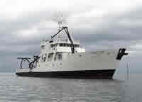
 Point Sur |
| Survey Equipment | Survey Info | Data Type(s) | Data Collected |
|---|---|---|---|
| Hand-grab sample | --- | Biology Chemistry Geology | |
| Nutrient sampler | --- | Chlorophyll Nutrients | |
| CTD_SeaBird | --- | CTD |