Other ID: none
Status: Completed
Organization(s): USGS, Woods Hole Coastal and Marine Science Center
Funding Program(s): Integrated sea floor characterization (LQ00UQN)
Principal Investigator(s): Jason Chaytor
Affiliate Investigator(s):
Information Specialist(s): Kelli Moran
Data Type(s): Sampling: Geology
Scientific Purpose/Goals: To collect sediment cores for mudflow hazard assessment
Vehicle(s):
Start Port/Location: Gulfport, MS
End Port/Location: Gulfport, MS
Start Date: 2024-07-14
End Date: 2024-07-21
Equipment Used: OSIL Mega Multiple Corer
Information to be Derived: sediment analysis data
Summary of Activity and Data Gathered: The 'Mega multicorer' was used to recover 17 cores (between 1 and 3 cores per location, depending on recovery). Of the 17 cores that were recovered, 8 were brought back to the WHMSC for archives and future sampling, 4 of them were subsampled in the field for sediment density (17 samples) and water chemistry (5 samples), and 5 were sent to Louisiana State University for processing (gamma density logging).
Staff: Kelli Moran, Alexander Nichols, Eric Moore
Affiliate Staff:
Notes:
Location:
Mississippi River Delta Front
| Boundaries | |||
|---|---|---|---|
| North: 29.36302704 | South: 28.45903302 | West: -89.97802734 | East: -88.28613281 |
Platform(s):
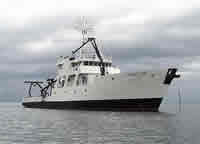
 Point Sur |
| Survey Equipment | Survey Info | Data Type(s) | Data Collected |
|---|---|---|---|
| OSIL Mega Multiple Corer | --- | Chemistry Geology Biology |