Other ID: GoMCT
Status: Pending
Organization(s): USGS, Woods Hole Coastal and Marine Science Center, National Oceanic and Atmospheric Administration
Funding Program(s): Other (Other)
Principal Investigator(s): Laura Brothers
Affiliate Investigator(s):
Information Specialist(s): William Danforth
Data Type(s): Sonar: Water column reflectivity, Sonar: Multibeam
Scientific Purpose/Goals: To collect baseline information about Gulf of Maine seafloor character.
Vehicle(s):
Start Port/Location: Avery Point, CT
End Port/Location: Avery Point, CT
Start Date: 2024-05-30
End Date: 2024-06-09
Equipment Used: EM2040
Information to be Derived: seafloor depth, backscatter, water column reflectivity
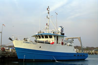
Summary of Activity and Data Gathered: Kongsberg EM2040-P multibeam echo sounder data were collected aboard the R/V Connecticut during the survey, the USGS was contacted by NOAA to help out with data collections activities. Bathymetric, backscatter, and water column data were collected and logged digitally to disk. The survey area covered a portion of the wind energy lease areas managed by BOEM. Data will be made available at NOAA's NCEI website at a later date after being released by BOEM. https://www.ncei.noaa.gov/access
Staff: Brian (Contractor) Curran
Affiliate Staff:
Notes: Bill Danforth and Brian Curran (contractor) will be going as additional seafloor mapping personnel on a NOAA/BOEM cruise aboard the RV Connecticut
Location:
Gulf of Maine
| Boundaries | |||
|---|---|---|---|
| North: 43.22919511 | South: 41.77131168 | West: -69.87304688 | East: -68.11523438 |
Platform(s):
 Connecticut |
| Survey Equipment | Survey Info | Data Type(s) | Data Collected |
|---|---|---|---|
| EM2040 | The EM2040-P multibeam echo sounder transmitter and receiver where mounted on a frame attached to the hull of the R/V Connecticut. Also attached to the frame was an AML micro sound speed transducer as well as an Seapath 300 inertial measurement unit (IMU) provided by Kongsberg. | Multibeam |