AKA: none
Other ID: CRLC 2024
Status: Completed
Organization(s): USGS, Pacific Coastal and Marine Science Center
Funding Program(s): Sediment Transport in Coastal Environments (ZP00FDB)
Principal Investigator(s): Andrew Stevens
Affiliate Investigator(s): Peter Ruggiero (OSU) George Kaminsky (WA DOE)
Information Specialist(s): Andrew Stevens
Data Type(s): Environmental Data: CTD, Sonar: Single Beam, Location-Elevation: Profiles, Location-Elevation: Navigation, Location-Elevation: Benchmarks
Scientific Purpose/Goals: Collect nearshore bathymetry and beach topography in the Columbia River littoral cell.
Vehicle(s): MarFac; Chevy Suburban - gray; 7 pass; G62-2874L
Start Port/Location: Astoria, OR
End Port/Location: Ocean Shores, WA
Start Date: 2024-08-01
End Date: 2024-08-09
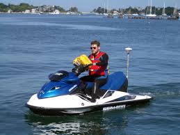
Equipment Used: YSI Sound velocity CTD, Waverunners, GPS, Trimble R7 GPS (AS), Radio (base)
Information to be Derived: Beach Topography, Nearshore Bathymetry
Summary of Activity and Data Gathered: Nearshore bathymetry and beach topography data collected.
Staff: Kai Parker, Timothy Elfers, Jackson Currie, Andrew Stevens
Affiliate Staff:
Notes: Entries for this field activity are based on entries from Field Activity 2023-644-FA.
Location:
Columbia River Littoral Cell
| Boundaries | |||
|---|---|---|---|
| North: 47.13742465 | South: 45.99696162 | West: -124.59594727 | East: -123.76098633 |
Platform(s):
 Waverunner 1 (SC) |  Waverunner 2 (SC) |
| Survey Equipment | Survey Info | Data Type(s) | Data Collected |
|---|---|---|---|
| YSI Sound velocity CTD | --- | CTD Sound Velocity | |
| Waverunners | --- | Navigation Single Beam | |
| GPS | --- | Navigation | |
| Trimble R7 GPS (AS) | --- | Benchmarks Navigation Profiles Transects | |
| Radio (base) | --- | Benchmarks LIDAR Navigation Profiles Transects |