Other ID: 2025-307-FA (SPCMSC); AT50-38 (WHOI)
Status: Pending
Organization(s): USGS, Woods Hole Coastal and Marine Science Center, Woods Hole Oceanographic Institution
Funding Program(s):
Principal Investigator(s): Amy Gartman, Christina Kellogg, Nancy Prouty, Amanda Demopolous
Affiliate Investigator(s): USGS: Cheryl Morrison (PI Retired) Jill Bourque, Samantha Schlegel, Aaron Aunins, Maria Figueroa, Katlin B. Adamczyk, Ashton Flinders, Brian Andrews, Seamus Jameson,
Information Specialist(s): Brian Andrews
Data Type(s): Sampling: Chemistry, Imagery: Photo, Imagery: Video, Seismics: Sub Bottom Profiler, Sonar: Water column reflectivity, Sonar: Multibeam, Sampling: Biology
Scientific Purpose/Goals: The Aleutian Arc is a tectonic convergence zone, including ecologically sensitive and economically important seafloor habitats, hazards, and resources including the prospective for hydrothermal marine minerals (Gartman et al., 2022). The Arc is one of the most remote and understudied regions of the U.S. Exclusive Economic Zone (EEZ). The unique combination of geologic and oceanographic features creates a heterogeneous environment of exposed rocky substrate, swift currents, and highly productive nutrient-rich waters, facilitating extensive deep-sea coral (DSC) and sponge grounds. Given that fishery bycatch of corals and sponges is a serious concern, exploration of these habitats will help inform future resource management decisions that could prevent long-term damage and impacts to ecosystem function. USGS scientists and collaborators will provide baseline and exploratory seafloor observations in targeted areas of Alaska in the Aleutian Arc that hold potential marine minerals. Geological surveys can improve geohazards assessments in this seismically active region, which will help protect life, property, and infrastructure of coastal and Tribal communities. Building upon USGS expertise in benthic ecology, oceanography, genomics, and hazards assessments, this study will enhance scientific understanding of benthic ecosystems, helping to inform NEPA-required analyses related to potential future lease sales, Exploration Plans, and Development and Production Plans and will help implement Executive Order 13817 “Federal Strategy to Ensure Secure and Reliable Supplies of Critical Minerals”. BOEM and USGS have multiple mission-critical interests, including resource evaluation (marine critical minerals, biological), hazards, and increased understanding of potentially affected environments. The primary objectives for this Alvin mission were as follows: 1) Explore and ground truth newly mapped features in the Central and Western Aleutians (e.g., submarine volcanoes, pinnacles, scarps), seafloor hazards, sensitive benthic ecosystems, as well as possible hydrothermal vents, cold seeps, and critical seabed mineral resources. 2) Apply ‘Omics technologies (e.g., eDNA, microbiome characterization, sequencing) to characterize communities, identify ecosystem resources and describe genetic connectivity of habitats and select fauna; and 3) Describe biodiversity and community ecology of associated fishes and invertebrate communities, including age structure and reproductive traits of select deep-sea corals and sponges. This work included characterization of water masses, distribution and food-web ecology of associated fishes and invertebrate communities, and cultivation of microbes as potential sources of novel natural products. 4) Conduct education and outreach activities before, during, and after the mission. These activities included ship/Alvin tours, a presentation at Unalaska Library, and Oceans Discovery Day. Additional outreach included USGS website updates and interviews with news media.
Vehicle(s):
Start Port/Location: Dutch Harbor, AK
End Port/Location: Dutch Harbor, AK
Start Date: 2025-06-13
End Date: 2025-07-03
Equipment Used: EM124 12 kHz multibeam
Information to be Derived: This expedition focused on exploring and groundtruthing seafloor environments for hydrothermal vents and seeps, and characterizing coral and sponge hardgrounds and visited 11 sites (depths ~697-3353 m) along approximately 1,100 km stretch of the Aleutian Arc between Unalaska (East) and Semisopochnoi Island (West) Islands.
Summary of Activity and Data Gathered: Operations included ship-based multibeam bathymetry to fill mapping data gaps, Alvin Human Occupied Vehicle (HOV) video transects, planned fluid and gas collections, and targeted biological and geological specimens, sediment, and water sampling. Alvin operated at both shallow water depths (e.g., Sunday Basin, 405 m) and deeper seamounts (South Amlia Island, 3,353 m). Alvin dive time was balanced with other planned operations (mapping, CTDs, and transits). CTD casts collected oceanographic and chemical data, along with water samples to characterize particulate organic matter (POM), carbonate chemistry, nutrients, and to provide eDNA samples to detect important fauna (deep-sea corals, commercially important and prey fishes, marine mammals) and augment food-web characterization. A total of 3,068 kms (18,103 sq kms) of depth, and backscatter data were collected with the ship's EM124 multibeam sonar. Mapping activities were primarily conducted during transits between Alvin dive sites. 11 Alvin dives were conducted collecting 444 biology, 29 geology, and 408 water samples, in addition 239 eDNA, 125 Radium, and 109 nutrient samples were collected. A full Cruise Report will have a complete summary of activities once it is published in 2026.
Staff:
Affiliate Staff:
NOAA: Tamara Baumberger
Alexis Weinnig
Ashley Marranzino
Cathleen Yung
Phillip Hoffman
BOEM: Christina Bonsell
Shannon Cofield. ON: Katlin Adamczyk
Smithsonian Institution: Stephanie Bush
Western Washington University: Evan Coit. Florida State University: Lauren Rice. University of Gothenburg: Rhian Waller Contractors: Art Howard
Ashley Marranzino
Notes: All raw data will be archived and made publicly available via NOAA, Ocean Exploration, and NCEI. USGS (Andrews, Flinders, Demopoulos) will publish the final processed EM124 depth and backscatter grids via the Marine Geoscience Data System (MGDS) in 2026.
Location:
Western Aleutians, Bering Sea, Pacific Ocean
| Boundaries | |||
|---|---|---|---|
| North: 54.11248 | South: 51.0958 | West: 178.714737 | East: -166.4689 |
Platform(s):
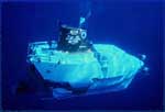 Alvin | 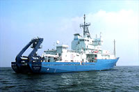 Atlantis |
| Survey Equipment | Survey Info | Data Type(s) | Data Collected |
|---|---|---|---|
| EM124 12 kHz multibeam | --- | Water column reflectivity Multibeam |
