Other ID: B-02-96-TX
Status: Completed
Organization(s): USGS, St. Petersburg Coastal and Marine Science Center
Funding Program(s): Other (Other)
Principal Investigator(s): Dana Wiese
Affiliate Investigator(s):
Information Specialist(s):
Data Type(s): Location-Elevation: Navigation, Seismics: Boomer
Scientific Purpose/Goals:
Vehicle(s):
Start Port/Location: Corpus Christi, TX
End Port/Location: Corpus Christi, TX
Start Date: 1996-07-10
End Date: 1996-07-16
Equipment Used: GPS , EG&G Geopulse, ITI ST-5 streamer
Information to be Derived: Shallow geologic framework
Summary of Activity and Data Gathered: Of the 44 boomer tracklines collected, only 10 (tx715_29 - tx715_38) could be rescued from the original magneto-optical (MO) discs. The remaining analog printouts were scanned as TIFF images and converted to digital SEG-Y files using CTI's ImageToSEGY software.
Staff:
Affiliate Staff:
Notes: Digital 96CCT02 logs were generated by
A. Harrison in March of 2007 using the handwritten logs and personal accounts of
the crew members.
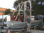
PLATFORM used, 32 - ft barge
Location:
Copano, Corpus Christi, and Nueces Bays and Corpus Christi Bayou, Texas
| Boundaries | |||
|---|---|---|---|
| North: 28.14336 | South: 27.76869 | West: -97.5405 | East: -97.05017 |
Platform(s):
 Barge |
Harrison, A.S., Dadisman, S.V., Kindinger, J.L., Morton, R.A., Bloom, M., Wiese, D.S., Subino, J., 2007, Archive of digital and digitized analog boomer seismic reflection data collected during USGS cruise 96CCT02 in Copano, Corpus Christi, and Nueces Bays and Corpus Christi Bayou, Texas, July 1996: U.S. Geological Survey Data Series 296, https://doi.org/10.3133/ds296.
FAN 96CCT02 has data viewable in the GeoMappApp/Virtual Ocean applications. To view this data in these applications go to http://www.geomapapp.org/ and http://www.virtualocean.org/. See the instructions for locating USGS data in these applications. You can also view the imagery created from the SEGY data at https://cmgds.marine.usgs.gov/images.php?cruise=96CCT02.
| Survey Equipment | Survey Info | Data Type(s) | Data Collected |
|---|---|---|---|
| GPS | --- | Navigation | Nav data |
| EG&G Geopulse | --- | Boomer Sub Bottom Profiler | |
| ITI ST-5 streamer | --- | Air Gun / Water Gun Boomer Sparker | Boomer seismic data |
