AKA: none
Other ID: A-1-97-SF,BASIX_III
Status: Completed
Organization(s): USGS, Pacific Coastal and Marine Science Center
Funding Program(s): Bay Area Seismic Imaging Experiment (BASIX) (MU017)
Principal Investigator(s): Patrick Hart, Jonathan Childs
Affiliate Investigator(s):
Information Specialist(s): Patrick Hart
Data Type(s): Seismics: Ocean Bottom Seismometer, Location-Elevation: Navigation
Scientific Purpose/Goals: 3D geometry of San Andreas/Hayward Fault System.
Vehicle(s):
Start Port/Location:
End Port/Location:
Start Date: 1997-08-31
End Date: 1997-09-15
Equipment Used: bottomseismometer, YoNav, GPS
Information to be Derived:
Summary of Activity and Data Gathered:
Staff: Ray Sliter, Thomas Parsons, Walt Olson, Kevin O'Toole, Hal Williams, Dave Hogg, Bill Robinson, Jeff Brody, Dennis Mann, Steve Wessels, Diane Minasian, Steve Bean
Affiliate Staff:
Bill Cooperwat (Stanford) - Geologist
Terence Shinn - Ship Captain
Mary Nichols - Cook
Notes: See also M-1-97-SF (McGaw)Jon Childs (USGS Western Region) - Chief Scientist
Ray Sliter (USGS Western Region) - Geophysicist
Tom Parsons (USGS Western Region) - Geophysicist
Walt Olson (USGS Western Region) - Mechanical Technician
Kevin O'Toole (USGS Western Region) - Mechanical Technician
Hal Williams (USGS Western Region) - Mechanical Technician
Dave Hogg (USGS Western Region) - Electrical Technician
Bill Robinson (USGS Western Region) - Electrical Engineer
Jeff Brody (USGS Western Region) - Computer Specialist
Dennis Mann (USGS Western Region) - Data Curator
Steve Wessels (USGS Western Region) - Photographer
Diane Minasian (USGS Western Region) - Geologist
Bill Cooperwat (Stanford) - Geologist
Terence Shinn - Ship Captain
Dave - Chief Engineer
Steve Bean - Chief Mate
Mary Nichols - Cook
Location:
San Francisco Bay
| Boundaries | |||
|---|---|---|---|
| North: 38.0664 | South: 37.51742 | West: -122.6562 | East: -121.82579 |
Platform(s):
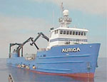 Auriga |
| Survey Equipment | Survey Info | Data Type(s) | Data Collected |
|---|---|---|---|
| bottomseismometer | --- | Ocean Bottom Seismometer | seis (data on FAD) Seismic FFID/Shot/CDP data a-1-97-sf.410_wideangle_bottomseismometer (Provisional best file) Raw seismic shot point data a-1-97-sf.400 |
| YoNav | --- | Navigation | Raw seismic shot point data a-1-97-sf.400_060 |
| GPS | --- | Navigation | Global positioning system (GPS) data a-1-97-sf.060 (Provisional best file) |
