AKA: none
Other ID: A-2-84-WF,Dive_1463
Status: Completed
Organization(s): USGS, Pacific Coastal and Marine Science Center
Funding Program(s):
Principal Investigator(s): Bill Normark
Affiliate Investigator(s):
Information Specialist(s):
Data Type(s): Imagery: Photo, Imagery: Video, Location-Elevation: Navigation, Sampling: Geology, Seismics: Sub Bottom Profiler
Scientific Purpose/Goals:
Vehicle(s):
Start Port/Location: Astoria, OR and Newport, OR
End Port/Location: San Diego, CA and Newport, OR
Start Date: 1984-09-15
End Date: 1984-10-01
Equipment Used: pipedredge, chaindredge, 3.5khz, underwatertelevision, underwatercamera, courserecorder, dopplersonar, LoranC, radar, transitsatellite, navigation, submersible
Information to be Derived:
Summary of Activity and Data Gathered: physical data holdings
Staff: William A, Reuben Baker, Jim Bischoff, John Bizzozero, Robin Brett, Henry Chezar, Roy Fields, Robin Holcomb, Ellen Kappel, Randy Koski, Jan Morton, Kevin O'Toole, Stephanie Ross, Pat Shanks, Rob Zierenberg
Affiliate Staff:
John Slack (USGS Eastern Region) - Geologist
Karen Von Damm - Geologist
Notes: Staff information imported from InfoBank
Bill Normark (USGS Western Region) - Chief Scientist
Ellen Kappel (USGS Western Region) - Geologist
Hank Chezar (USGS Western Region) - Oceanographer
Jan Morton (USGS Western Region) - Geophysicist
Jim Bischoff (USGS Western Region) - Geologist
John Bizzozero - Chief Engineer
John Slack (USGS Eastern Region) - Geologist
Karen Von Damm - Geologist
Kevin O'Toole (USGS Western Region) - Mechanical Technician
Pat Shanks (USGS Eastern Region) - Geologist
Randy Koski (USGS Western Region) - Geologist
Reuben Baker Jr - Ship Captain
Rob Zierenberg (USGS Western Region) - Geologist
Robin Brett (USGS Western Region) - Geologist
Robin Holcomb (USGS Western Region) - Geologist
Roy Fields (USGS Western Region) - Electronics Technician
Stephanie Ross (USGS Western Region) - Geophysicist
William A Gillard Jr - Chief Mate
Location:
Juan De Fuca
| Boundaries | |||
|---|---|---|---|
| North: 44.9225 | South: 44.5235 | West: -130.456 | East: -125.29217 |
Platform(s):
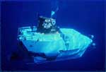 Alvin | 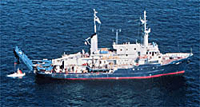 Atlantis II |
Bischoff, J.L., and Rosenbauer, R.J., 1989, Salinity variations in submarine hydrothermal systems by layered double-diffusive convection: Journal of Geology, Journal of Geology, v. 97 no. 5, pp. 613–623, URL: http://www.jstor.org/stable/30078367.
Chezar, H., and Newman, I., 2004, Activity A-2-84-WF, ship station 10: DVD-Video Disc set of seafloor transects during USGS research cruises in the Pacific Ocean: U.S. Geological Survey Open-File Report 2004-1114, https://pubs.er.usgs.gov/publication/ofr20041114AE.
Chezar, H., and Newman, I., 2004, Activity A-2-84-WF, ship station 11: DVD-Video Disc set of seafloor transects during USGS research cruises in the Pacific Ocean: U.S. Geological Survey Open-File Report 2004-1115, https://pubs.er.usgs.gov/publication/ofr20041115AC.
Chezar, H., and Newman, I., 2004, Activity A-2-84-WF, ship station 1: DVD-Video Disc set of seafloor transects during USGS research cruises in the Pacific Ocean: U.S. Geological Survey Open-File Report 2004-1108, https://pubs.er.usgs.gov/publication/ofr20041108AE.
Chezar, H., and Newman, I., 2004, Activity A-2-84-WF, ship station 4: DVD-Video Disc set of seafloor transects during USGS research cruises in the Pacific Ocean: U.S. Geological Survey Open-File Report 2004-1109, https://pubs.er.usgs.gov/publication/ofr20041109AE.
Chezar, H., and Newman, I., 2004, Activity A-2-84-WF, ship station 5: DVD-Video Disc set of seafloor transects during USGS research cruises in the Pacific Ocean: U.S. Geological Survey Open-File Report 2004-1110, https://pubs.er.usgs.gov/publication/ofr20041110AB.
Chezar, H., and Newman, I., 2004, Activity A-2-84-WF, ship station 7: DVD-Video Disc set of seafloor transects during USGS research cruises in the Pacific Ocean: U.S. Geological Survey Open-File Report 2004-1111, https://pubs.er.usgs.gov/publication/ofr20041111AE.
Chezar, H., and Newman, I., 2004, Activity A-2-84-WF, ship station 8: DVD-Video Disc set of seafloor transects during USGS research cruises in the Pacific Ocean: U.S. Geological Survey Open-File Report 2004-1112, https://pubs.er.usgs.gov/publication/ofr20041112AE.
Chezar, H., and Newman, I., 2004, Activity A-2-84-WF, ship station 9: DVD-Video Disc set of seafloor transects during USGS research cruises in the Pacific Ocean: U.S. Geological Survey Open-File Report 2004-1113, https://pubs.er.usgs.gov/publication/ofr20041113AE.
Chezar, H., and Newman, I., 2006, Overview: DVD-video disc set of seafloor transects during USGS research cruises in the Pacific Ocean: U.S. Geological Survey Open-File Report 2004-1101, https://pubs.usgs.gov/of/2004/1101/.
Holcomb, R.T., Kappel, E.S., and Ross, S.L., 1986, Dive report: Alvin Dive #1461, September 28, 1984 (JD 272), Plume Site, southern Juan de Fuca Rift: U.S. Geological Survey Open-File Report 86-560-H, 101 p., https://pubs.er.usgs.gov/publication/ofr86560H.
Kappel, E.S., and Normark, W.R., 1987, Morphometric variability within the axial zone of the southern Juan de Fuca Ridge; interpretation from Sea MARC II, Sea MARC I, and deep-sea photography: Journal of Geophysical Research, B, Solid Earth and Planets, v. 92 no. 11, pp. 11,291–11,302, doi: 10.1029/JB092iB11p11291.
Kappel, E.S., and Normark, W.R., 1988, Results from camera tows along the southern Juan de Fuca Ridge; A2-84-WF: U.S. Geological Survey Open-File Report 88-371, https://pubs.er.usgs.gov/publication/ofr88371.
Morton, J.L., Normark, W.R., and Holcomb, R.T., 1986, Geology, structure, and volcanic processes of southern Juan de Fuca Ridge: American Association of Petroleum Geologists Bulletin, v. 70 no. 7, pp. 427–428, URL: http://archives.datapages.com/data/circ_pac/0019/0427e.pdf.
Morton, J.L., Normark, W.R., Mann, D.M., and Tompkins, D.H., 1987, Geology, evolution, and mineral potential of the Juan de Fuca Ridge: Circum-Pacific Council for Energy and Mineral Resources, Earth Science Series, pp. 537–547, URL: http://archives.datapages.com/data/circ_pac/0007/0537_f.html.
Normark, W.R., and Morton, J.L., 1987, Detailed structural mapping of an ocean rift, using acoustic-transponder positioning; problems of net maintenance (1981-86) and new experiments possible with long-life transponders, in Kumar, Muneendra, and Maul, George A., Proceedings: International symposium on Marine positioning: Dordrecht, Netherlands, D. Reidel Publ. Co.
Normark, W.R., Morton, J.L., and Ross, S.L., 1987, Submersible observations along the southern Juan de Fuca Ridge; 1984 Alvin Program: Journal of Geophysical Research, B, Solid Earth and Planets, v. 92 no. B11, pp. 11,283–11,290, doi: 10.1029/JB092iB11p11283.
Normark, W.R., Morton, J.L., and Saxena, N.K., 1990, Scaling considerations for acoustic measurement of ridge extension: American Geophysical Union Eos, Transactions 71(43), pp. 1602–1602.
Normark, W.R., Morton, J.L., Bischoff, J.L., Brett, R., Holcomb, R.T., Kappel, E.S., Koski, R.A., and Ross, S.L., 1986, Submarine fissure eruptions and hydrothermal vents on the southern Juan de Fuca Ridge; preliminary observations from the submersible Alvin: Geology, v. 14 no. 10, pp. 823–827, doi: 10.1130/0091-7613%281986%2914%3C823:Sfeahv%3E2.0.Co;2.
Normark, W.R., Morton, J.L., Bischoff, R.B., Holcomb, R.T., Koski, R.A., Ross, S.L., Shanks III, W.C., Slack, J.F., Von Damm, K.L., Zierenberg, R.A., and, Kappel, E.S., 1985, Submarine fissure eruption and associated hydrothermal vents along the southern Juan de Fuca Ridge: American Geophysical Union Eos, Transactions 66(10), pp. 116–116.
Normark, W.R., Morton, J.L., Holcomb, R.T., Koski, R.A., and Ross, S.L., 1984, A continuous linear depression in the axial valley of the southern Juan de Fuca Ridge; tectonic or volcanic origin? Geological Society of America Abstracts with Programs, 97th meeting 16(6), pp. 611–611.
von Damm, K.L., and Bischoff, J.L., 1985, Southern Juan de Fuca Ridge hot spring chemistry: American Geophysical Union Eos, Transactions 66(46), pp. 926–926.
| Survey Equipment | Survey Info | Data Type(s) | Data Collected |
|---|---|---|---|
| pipedredge | --- | Geology | |
| chaindredge | --- | Geology | chain dredge locations |
| 3.5khz | --- | Sub Bottom Profiler | bathy info |
| underwatertelevision | --- | Video | underwater camera underwater television |
| underwatercamera | --- | Photo | |
| courserecorder | --- | Navigation | |
| dopplersonar | --- | Navigation | |
| LoranC | --- | Navigation | |
| radar | --- | Navigation | |
| transitsatellite | --- | Navigation | |
| navigation | --- | Navigation | Satellite data a-2-84-wf.000 Eotvos/course/speed/distance data a-2-84-wf.070 Eotvos/course/speed/distance data a-2-84-wf.071 (Provisional best file) |
| submersible | --- | Photo Video Biology Geology | ALV1457 (massive sulfide samples) |
