AKA: none
Other ID: B-05-11-SF
Status: Completed
Organization(s): USGS, Pacific Coastal and Marine Science Center, San Francisco Estuary Institute
Funding Program(s):
Principal Investigator(s): Renee Takesue
Affiliate Investigator(s):
Information Specialist(s): Amy Foxgrover
Data Type(s): Location-Elevation: Navigation, Sampling: Geology
Scientific Purpose/Goals: to collect surface sediment samples
Vehicle(s):
Start Port/Location:
End Port/Location:
Start Date: 2011-08-22
End Date: 2011-08-31
Equipment Used: GPS, vanveengrab
Information to be Derived: sediment grain size, mineralogy, etc.
Summary of Activity and Data Gathered: These surface samples (top 2 cm) were collected for use in the USGS San Francisco Bay Coastal System Fine Sediment Provenance Study. Samples were collected aboard the R/V Endeavor (owned and operated by the US Bureau of Reclamation) on a cruise coordinated by the San Francisco Estuary Institute as part of the regional monitoring program; see URL: http://www.sfei.org/rmp/ and contracted to Applied Marine Sciences: see URL: http://www.amarine.com
Staff: Amy Foxgrover
Affiliate Staff:
Notes: These samples will be collected by the San Francisco Estuary Institute (aboard their vessel) as part of their regional monitoring program. We are piggybacking on their cruise to collect samples for use in the San Francisco Coastal System Provenance Study
Staff information imported from InfoBank
Amy Foxgrover
Location:
San Francisco Bay
| Boundaries | |||
|---|---|---|---|
| North: 38.13376 | South: 37.46824 | West: -122.465 | East: -121.80837 |
Platform(s):
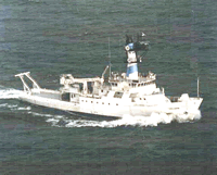 Endeavor |
| Survey Equipment | Survey Info | Data Type(s) | Data Collected |
|---|---|---|---|
| GPS | --- | Navigation | Best file with nav in ArcInfo E00 forma (Arc Files) Global positioning system (GPS) data (Provisional best file) |
| vanveengrab | --- | Geology | Best file with nav in ArcInfo E00 format (Arc Files) vanveengrab (Metadata) |
