AKA: none
Other ID: B-1-00-NC
Status: Completed
Organization(s): USGS, Pacific Coastal and Marine Science Center
Funding Program(s):
Principal Investigator(s): Larry Phillips
Affiliate Investigator(s):
Information Specialist(s):
Data Type(s): Location-Elevation: Navigation, Sampling: Geology
Scientific Purpose/Goals: Bottom coring
Vehicle(s):
Start Port/Location:
End Port/Location:
Start Date: 2000-09-19
End Date: 2000-09-21
Equipment Used: GPS, vibratingcore
Information to be Derived:
Summary of Activity and Data Gathered: Collected 7 vibracores successfully.
Staff:
Affiliate Staff:
Notes:
Staff information imported from InfoBank
Larry Phillips (USGS Western Region) - Chief Scientist
Location:
Northern California
| Boundaries | |||
|---|---|---|---|
| North: 41.5836 | South: 41.58154 | West: -121.603 | East: -121.58893 |
Platform(s):
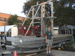 Barge |
| Survey Equipment | Survey Info | Data Type(s) | Data Collected |
|---|---|---|---|
| GPS | --- | Navigation | Best file with nav in ArcInfo E00 format (Arc Files) Global positioning system (GPS) data (Provisional best file) |
| vibratingcore | --- | Geology | Best file with nav in ArcInfo E00 format (Arc Files) vibratingcore (Metadata) |
