AKA: none
Other ID: B-2-05-WA
Status: Completed
Organization(s): USGS, Pacific Coastal and Marine Science Center
Funding Program(s): Deschutes Estuary Restoration Feasibility Study (MU086)
Principal Investigator(s): Guy Gelfenbaum
Affiliate Investigator(s):
Information Specialist(s):
Data Type(s): Location-Elevation: Navigation, Sampling: Geology
Scientific Purpose/Goals: Collect subsurface sediment for input to sediment transport model
Vehicle(s):
Start Port/Location: boat landing near Tumwater Historical Park
End Port/Location: boat landing near Tumwater Historical Park
Start Date: 2005-06-13
End Date: 2005-06-20
Equipment Used: GPS, core
Information to be Derived: sediment grain size
Summary of Activity and Data Gathered: 18 D-tubes with split cores and 2 small plastic bins with subsamples.
Staff:
Affiliate Staff:
Notes: ECY contact-Dale Davis 7-6972 Doug George x5376 Washington State Department of Transportation Barge
Location:
Washington
| Boundaries | |||
|---|---|---|---|
| North: 47.04511 | South: 47.02185 | West: -122.911 | East: -122.90061 |
Platform(s):
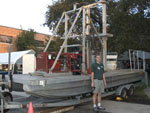 Barge |
| Survey Equipment | Survey Info | Data Type(s) | Data Collected |
|---|---|---|---|
| GPS | --- | Navigation | Global positioning system (GPS) data (Provisional best file) |
| core | --- | Biology Geology | core (Metadata) |
