AKA: none
Other ID: C-1-08-PS
Status: Completed
Organization(s): USGS, Pacific Coastal and Marine Science Center, Coast Salish Canoe Families and Skippers
Funding Program(s): Coast Salish Tribal Journey Water Quality Project (MU061)
Principal Investigator(s): Eric Grossman
Affiliate Investigator(s):
Information Specialist(s): PARTNER
Data Type(s):
Scientific Purpose/Goals: Collect georeferenced water quality data of surface waters along 5 or 6 canoe journey pathways across the Salish Sea between July 14 and July 28, 2008
Vehicle(s):
Start Port/Location: Squaxin Isl. and Swinomish Reservation, Skokomish, WA and Cambell River, Stolo, British Columbia, CANADA
End Port/Location: Cowichan, BC, CANADA and Cowichan, BC, CANADA and Cowichan, BC, CANADA
Start Date: 2008-07-14
End Date: 2008-07-28
Equipment Used:
Information to be Derived: Surface water temperature, conductivity, salinity, dissolved oxygen, turbidity, pH, oxidation reduction potential, resistivity
Summary of Activity and Data Gathered:
Staff:
Affiliate Staff:
Notes:
Non USGS data manager = Sarah Akin (Coast Salish Tribal Journey Water Quality Program Coordinator)
Location:
Canada
| Boundaries | |||
|---|---|---|---|
| North: 49.75 | South: 47.25 | West: -125.75 | East: -122.25 |
Platform(s):
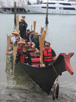 Canoe |
Akin, S.K., Grossman, E.E., Lekanof, D., O'Hara, C., 2009, Coast Salish and U.S. Geological Survey: Tribal Journey Water Quality Project: Coast Salish Gathering Report 2009-001, 58 p.
| Survey Equipment | Survey Info | Data Type(s) | Data Collected |
|---|
