AKA: none
Other ID: C-1-88-SP,RC2901
Status: Completed
Organization(s): USGS, Pacific Coastal and Marine Science Center
Funding Program(s):
Principal Investigator(s): S. Cande, Steve Lewis
Affiliate Investigator(s):
Information Specialist(s):
Data Type(s): Electro-Magnetic: Gravity, Electro-Magnetic: Magnetics, Location-Elevation: Navigation, Sonar: Single Beam
Scientific Purpose/Goals: The main focus of RC2901 was a geophysical study of the interaction between the Chilean ridge and trench. The inner trench slope accretionary processes and the extent of the continental crust were of particular interest. Multichannel seismic surveys were conducted in four areas: 35 -40 S were surveyed as a subcontract for the Chilean oil company, ENAP; three areas at 44 30S, 46 S, and 48 S were surveyed as possible ODP drilling sites. Magnetics, gravity and Sea Beam were run at all times during these surveys. An intensive seven day Sea Beam survey was conducted from 45 30S to 47 S in the area where the Chile trench is actively subducting a segment of the Chilean ridge. Single channel seismic, magnetics and gravity data were also collected during the survey.
Vehicle(s):
Start Port/Location:
End Port/Location:
Start Date: 1988-01-07
End Date: 1988-02-10
Equipment Used: GPS, magnetics, gravity, transitsatellite, bathnav
Information to be Derived:
Summary of Activity and Data Gathered:
Staff:
Affiliate Staff:
Notes: Lamont-Doherty Geological Observatory
Staff information imported from InfoBank
S. Cande - Chief Scientist
Steve Lewis - Chief Scientist
Location:
Central Pacific
| Boundaries | |||
|---|---|---|---|
| North: -32.95733 | South: -53.92482 | West: -76.7609 | East: -70.82263 |
Platform(s):
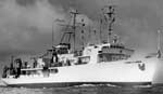 Robert D Conrad |
| Survey Equipment | Survey Info | Data Type(s) | Data Collected |
|---|---|---|---|
| GPS | --- | Navigation | Integrated navigation (SINS) data c-1-88-sp.050 (Provisional best file) |
| magnetics | --- | Magnetics | Edited magnetics data c-1-88-sp.221_050 (Provisional best file) Edited magnetics data c-1-88-sp.220 Edited magnetics data c-1-88-sp.220_050 |
| gravity | --- | Gravity | Free Air Anomaly data c-1-88-sp.160 Free Air Anomaly data c-1-88-sp.160_050 (Provisional best file) |
| transitsatellite | --- | Navigation | |
| bathnav | --- | Navigation Single Beam | Edited bathymetry data with corrected depths c-1-88-sp.320_050 (Provisional best file) |
