AKA: none
Other ID: C-1-92-WF,Dive 665
Status: Completed
Organization(s): USGS, Pacific Coastal and Marine Science Center
Funding Program(s):
Principal Investigator(s): Jan Morton
Affiliate Investigator(s):
Information Specialist(s):
Data Type(s): Sonar: Single Beam, Location-Elevation: Navigation, Environmental Data: CTD, Time Series: Mooring (physical oceanography)
Scientific Purpose/Goals:
Vehicle(s):
Start Port/Location:
End Port/Location:
Start Date: 1992-05-16
End Date: 1992-05-24
Equipment Used: Sonatracktransducer, GPS, CTD, tripod
Information to be Derived:
Summary of Activity and Data Gathered:
Staff: Carol Reiss, Stephanie Ross, Chris Gutmacher, Ransom Rideout, Robin Holcomb, Ed Berg
Affiliate Staff:
Beecher Wooding (WHOI) - Unspecified Investigator
Steven Trucker (Naval Postgrad School) - Unspecified Investigator
Notes: Locations 1-4 are the tripod deployments of the dual frequency transponders. Used a U.S. Navy Advanced Tethered Vehicle, U.S. Navy D SV-3 Turtle submarine
Staff information imported from InfoBank
Jan Morton (USGS Western Region) - Chief Scientist
Carol Reiss (USGS Western Region) - Unspecified Investigator
Stephanie Ross (USGS Western Region) - Unspecified Investigator
Chris Gutmacher (USGS Western Region) - Unspecified Investigator
Ransom Rideout (USGS Western Region) - Unspecified Investigator
Robin Holcomb (USGS Western Region) - Unspecified Investigator
Beecher Wooding (WHOI) - Unspecified Investigator
Steven Trucker (Naval Postgrad School) - Unspecified Investigator
Ed Berg (University of Hawaii) - Unspecified Investigator
Location:
Washington
| Boundaries | |||
|---|---|---|---|
| North: 44.67288 | South: 44.66453 | West: -130.3641 | East: -130.35233 |
Platform(s):
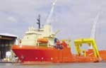 Laney Chouest |
| Survey Equipment | Survey Info | Data Type(s) | Data Collected |
|---|---|---|---|
| Sonatracktransducer | --- | Single Beam | |
| GPS | --- | Navigation | |
| CTD | --- | Surveys (geochemical) Experiments (geochemical) CTD | |
| tripod | --- | Mooring (physical oceanography) |
