AKA: none
Other ID: F-1-10-CA
Status: Completed
Organization(s): USGS, Pacific Coastal and Marine Science Center
Funding Program(s):
Principal Investigator(s): Jonathan Childs
Affiliate Investigator(s):
Information Specialist(s): David Finlayson
Data Type(s): Sonar: Multibeam
Scientific Purpose/Goals: Exploratory cruise to test swath mapping capability in hyper-saline environments
Vehicle(s):
Start Port/Location: LEAVE Lee Vining, CA
End Port/Location: ARRIVE Lee Vining, CA
Start Date: 2010-09-27
End Date: 2010-10-01
Equipment Used: Swath
Information to be Derived: Hi Resolution sea floor bathymetry
Summary of Activity and Data Gathered:
Staff: Michael Boyle, Peter Dal Ferro, David Finlayson
Affiliate Staff:
Notes: Staff information imported from InfoBank
David Finlayson
Mike Boyle
Pete Dal Ferro
Location:
CA
| Boundaries | |||
|---|---|---|---|
| North: 38.1 | South: 37.9 | West: -119.2 | East: -118.85 |
Platform(s):
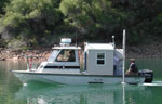 Frontier |
| Survey Equipment | Survey Info | Data Type(s) | Data Collected |
|---|---|---|---|
| Swath | --- | Multibeam |
