USGS - science for a changing world

USGS Coastal and Marine Geology Program

Field Activity Details for field activity F1389HW

View new CMGDS report form

AKA: none

Other ID: F-13-89-HW

Status: Completed

Organization(s):

Funding Program(s): Geological Long-Range Inclined Asdic (GLORIA) (MU116)

Principal Investigator(s): Dave Drake, Ledabeth Pickthorn

Affiliate Investigator(s):

Information Specialist(s):

Data Type(s): Seismics: Sub Bottom Profiler, Sonar: Single Beam, Electro-Magnetic: Gravity, Electro-Magnetic: Magnetics, Environmental Data: Conductivity, Environmental Data: Temperature, Location-Elevation: Navigation, Sonar: Sidescan, Seismics: Air Gun / Water Gun, Seismics: Multichannel

Scientific Purpose/Goals:

Vehicle(s):

Start Port/Location:

End Port/Location:

Start Date: 1989-11-28

End Date: 1989-12-21

Equipment Used: 3.5khz, 10khz, gravity, magnetics, tempsalinometer, GPS, integratednavigation, LoranC, RhoRho, Gloriasidescan, airgun, 2channelairgun, expendablebatthermograph

Information to be Derived:

Summary of Activity and Data Gathered:

Staff:

Affiliate Staff:

Notes: Associated cruises: F-5-86-HW F-6-86-HW F-3-88-HW F-4-88-HW F-5-88-HW F-6-88-HW F-10-88-HW F-12-89-HW F-13-89-HW F-1-90-HW F-2-90-HW F-6-91-CP F-10-91-HW

Staff information imported from InfoBank
Dave Drake (USGS Western Region) - Chief Scientist
Ledabeth Pickthorn (USGS Western Region) - Chief Scientist

Location:

Hawaii

Boundaries
North: 26.116 South: 20.2269 West: 178.7988 East: -159.7504

Platform(s):

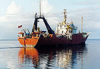
photo of Farnella
Farnella

Publications

Binard, N., Moore, J.G., Normark, W.R., and Holcomb, R.T., 1993, Comparison of features identified by swath-sonar mapping (GLORIA) and their 3.5 kHz echo-sounding features on the Hawaiian Ridge: American Geophysical Union Eos, Transactions, v. 74 no. 43, pp. 342–342.

Paskevich, V.F., Wong, F.L., O'Malley, J.J., Stevenson, A.J., and Gutmacher, C.E., 2011, GLORIA sidescan-sonar imagery for parts of the U.S. Exclusive Economic Zone and adjacent areas: U.S. Geological Survey Open-File Report 2010-1332, http://pubs.usgs.gov/of/2010/1332/.

Portals/Viewers

Data Acquired

Survey EquipmentSurvey InfoData Type(s)Data Collected
3.5khz --- Sub Bottom Profiler
Survey information
10khz --- Single Beam
Survey information
Edited bathymetry data with corrected depths f-13-89-hw.320
Edited bathymetry data with corrected depths f-13-89-hw.320_081 (Provisional best file)
NGDC MGD77 data - bathy
gravity --- Gravity
Raw gravity data from digital meter f-13-89-hw.101
Raw gravity data from digital meter f-13-89-hw.102
Gravity lines start/end control data f-13-89-hw.130
Gravity land tie data f-13-89-hw.140
SKIPNSAVED Free Air Anomaly data f-13-89-hw.150
SKIPNSAVED Free Air Anomaly data f-13-89-hw.150_081 (Provisional best file)
Survey information
Tape list
NGDC MGD77 data - gravity
magnetics --- Magnetics
Raw magnetics data f-13-89-hw.201_081
Raw magnetics data f-13-89-hw.201
Edited magnetics data f-13-89-hw.220
Edited magnetics data f-13-89-hw.221_081 (Provisional best file)
Edited magnetics data f-13-89-hw.222
Edited magnetics data f-13-89-hw.222_081
Raw gradiometer data f-13-89-hw.240_081
Survey information
Edited gradiometer data f-13-89-hw.260_081 (Provisional best file)
NGDC MGD77 data - Magnetics
tempsalinometer --- Conductivity
Temperature
GPS --- Navigation
Survey information
Global positioning system (GPS) data f-13-89-hw.060
integratednavigation --- Navigation
Integrated navigation (SINS) data f-13-89-hw.050
Farnella ABC data f-13-89-hw.081 (Provisional best file)
Farnella ABC data f-13-89-hw.081_degree
Lines
Survey information
Best file with nav in ArcInfo E00 format
Farnella ABC data f-13-89-hw.080
LoranC --- Navigation
RhoRho --- Navigation
Loran C data f-13-89-hw.030-hyp
Loran C data f-13-89-hw.030-rho
Survey information
Gloriasidescan --- Sidescan
Survey information
File list
Gloria (data on FAD)
Sidescan mosaic
airgun --- Air Gun / Water Gun
Survey information
2channelairgun --- Multichannel
Survey information
seismic (data on FAD)
expendablebatthermograph --- Temperature
Station Information

Accessibility FOIA Privacy Policies and Notices

U.S. Department of the Interior | U.S. Geological Survey
Questions or Comments? Contact CMGDS Team
https://cmgds.marine.usgs.gov