AKA: none
Other ID: GLCHLEG_10,G-10-70-GM
Status: Completed
Organization(s): USGS, Corpus Christi, TX
Funding Program(s): Deep Sea Drilling Project (MU082)
Principal Investigator(s): Kendall Dickenson
Affiliate Investigator(s): Lamar Worzel (Chief Scientist, LDGO) - Co,William Bryant (Chief Scientist, Texas AM) - Co
Information Specialist(s):
Data Type(s): Location-Elevation: Navigation
Scientific Purpose/Goals: Drilling
Vehicle(s):
Start Port/Location: Galveston, Texas
End Port/Location: Miami, Florida
Start Date: 1970-02-13
End Date: 1970-04-05
Equipment Used: navigation
Information to be Derived:
Summary of Activity and Data Gathered:
Staff: Joe Clarke
Affiliate Staff:
Notes:
Staff information imported from InfoBank
Kendall Dickenson - Chief Scientist
Joe Clarke (Glomar Challenger) - Captain
Lamar Worzel (Chief Scientist, LDGO) - Co
William Bryant (Chief Scientist, Texas AM) - Co
Location:
Gulf of America (Gulf of Mexico)
| Boundaries | |||
|---|---|---|---|
| North: 25.8448 | South: 20.8902 | West: -95.1122 | East: -84.4457 |
Platform(s):
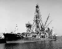 Glomar Challenger |
| Survey Equipment | Survey Info | Data Type(s) | Data Collected |
|---|---|---|---|
| navigation | --- | Navigation |
