AKA: none
Other ID: G-19-71-BS,15050017
Status: Completed
Organization(s): USGS, Pacific Coastal and Marine Science Center, Scripps Institution Of Oceanography, La Jolla, Ca
Funding Program(s): Deep Sea Drilling Project (MU082)
Principal Investigator(s): David Scholl
Affiliate Investigator(s): Joe Creager
Information Specialist(s):
Data Type(s): Electro-Magnetic: Magnetics, Location-Elevation: Navigation, Sampling: Geology, Seismics: Air Gun / Water Gun, Sonar: Single Beam
Scientific Purpose/Goals:
Vehicle(s):
Start Port/Location: Kodiak, Alaska
End Port/Location: Yokohama, Japan
Start Date: 1971-07-22
End Date: 1971-09-09
Equipment Used: magnetics, Other, airgun, navigation, corer, bathymetry
Information to be Derived:
Summary of Activity and Data Gathered:
Staff:
Affiliate Staff:
Notes: was also known as G1971NP
Staff information imported from InfoBank
Joe Creager - Chief Scientist
Dave Scholl (USGS Western Region) - Chief Scientist
Location:
Alaska
| Boundaries | |||
|---|---|---|---|
| North: 57.6089164 | South: 44.0507 | West: -179.426 | East: -152.3364 |
Platform(s):
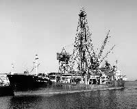 Glomar Challenger |
| Survey Equipment | Survey Info | Data Type(s) | Data Collected |
|---|---|---|---|
| magnetics | --- | Magnetics | NGDC MGD77 data - Magnetics Raw magnetics data g-19-71-bs.200 Edited magnetics data g-19-71-bs.220_050 (Provisional best file) Raw magnetics data g-19-71-bs.200_050 |
| Other | --- | --- | --- |
| airgun | --- | Air Gun / Water Gun | |
| navigation | --- | Navigation | Integrated navigation (SINS) data g-19-71-bs.050 (Provisional best file) Best file with nav in ArcInfo E00 format Integrated navigation (SINS) data g-19-71-bs.050_degree |
| corer | --- | Geology | Station Information |
| bathymetry | --- | Single Beam | NGDC MGD77 data - bathy Raw depth (bathymetry) data g-19-71-bs.305 Raw depth (bathymetry) data g-19-71-bs.305_050 (Provisional best file) |
