AKA: DSDP21GC, G-21-71-SP
Other ID: none
Status: Completed
Organization(s): USGS, Pacific Coastal and Marine Science Center
Funding Program(s): Deep Sea Drilling Project (MU082)
Principal Investigator(s):
Affiliate Investigator(s): James Andrews, Robert Burns
Information Specialist(s):
Data Type(s): Location-Elevation: Navigation, Seismics: Air Gun / Water Gun, Sonar: Single Beam, Electro-Magnetic: Magnetics
Scientific Purpose/Goals:
Vehicle(s):
Start Port/Location: Suva, Fiji
End Port/Location: Darwin, Australiz
Start Date: 1971-11-15
End Date: 1972-01-07
Equipment Used: transitsatellite, airgun, 12khz, bathymetry, magnetics
Information to be Derived:
Summary of Activity and Data Gathered: data holdings publications: Core Data from the Deep Sea Drilling Project, Leg 21: http://www.ngdc.noaa.gov/mgg/geology/dsdp/data/21/leg21.htm
Staff:
Affiliate Staff:
Notes: FAC created 11/15/2018 from InfoBank by CR.
Scripps Institution of Oceanography. Dates are based on the start and end of airgun data.
DATA COLLECTION OVERVIEW (use NGDC GEODAS CD to retrieve data)
MCG Data Collection ID --- G2171SP
Institution Data Collection ID --- DSDP21GC
NGDC ID --- 15050019
Funding --- (unspecified)
Project, Cruise & Leg --- DEEPSEA DRILL.LG 21
Study region --- -9.00000,-41.00000,+145.00000,-174.00000
Chief Scientist(s) --- ANDREWS J.,BURNS B.
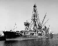
Name of vessel --- D/V GLOMAR CHALLENGER (surface ship)
Date field data collection started --- 11/16/71 SUVA,FIJI
Date field data collection ended --- 01/06/72 DARWIN,AUSTRALIA
Parameters surveyed ---
Bathymetry: surveyed, contained in data file
Magnetics: surveyed, contained in data file
Gravity: not surveyed
High-resolution seismics: not surveyed
Deep penetration seismics: surveyed, but not contained in data file
Format ---
(I1,A8,F5.2,4I2,F5.3,F8.5,F9.5,I1,F6.4,F6.1,I2,i1,3F6.1,I1,F5.1,F6.0,F7.1,F6.1,F5.1,A8,4I1)
Date of data input to NGDC --- 11/22/79
Contributing institution --- SCRIPPS INSTITUTION OF OCEANOGRAPHY
Country --- USA
Navigation instrumentation --- SATNAV,MANUAL ENTRY GYRO AND SPD CHANGES
Position determination method --- LINEAR INTERP.BETWEEN ADJACENT FIXES
Bathymetry instrumentation --- 12KHZ/GIFFT RECORDER/WIDE(60DEG)BEAM
Additional forms of bathymetric data --- ANAL.RECORDS,CARDS,35MMFILM
General rate of bathymetry in file --- 5.0 minutes
General collection rate of bathymetry --- 1SECONDSWEEP
Assumed sound velocity --- 1463.0 m/sec
Bathymetric datum code --- No correction applied (sea level)
Bathmetry interpolation scheme --- 5 MINUTE INTERVAL
Magnetics instrumentation --- VARIAN MFD PROTON PRECESSION MOD 4970
Additional forms of magnetics data --- ANAL.RECORDS,CARDS,35MMFILM
General rate of magnetics in file --- 5.0 minutes
General collection rate of magnetics --- 6 seconds
Magnetic sensor tow distance --- (unspecified)
Magnetic sensor depth --- (unspecified)
Two sensor horizontal separation --- (unspecified)
Residual magnetics reference field --- IGRF-65
Method of applying residual field --- LIN.INTERP.AT 30DEG C/C OR 500MI ALONG
TRACK
Seismic instrumentation --- 20TO300CU.IN.AIRGUN,10-300HZ,EDO PSR REC
Formats of seismic data --- ANAL.RECORDS,35MM MICROFILM
Notes ---
*TIME*NAV AND RECORDS ORIGINALLY IN LOCAL TZ. DIGITIZED DATA CONVERTED TO GMT.
Location:
Papua New Guinea, Southern Pacific
| Boundaries | |||
|---|---|---|---|
| North: -8.0374734 | South: -11.35079672 | West: 144.93148185 | East: 149.32665576 |
Platform(s):
 Glomar Challenger |
| Survey Equipment | Survey Info | Data Type(s) | Data Collected |
|---|---|---|---|
| transitsatellite | --- | Navigation | |
| airgun | --- | Air Gun / Water Gun | |
| 12khz | --- | Single Beam | |
| bathymetry | --- | Single Beam | |
| magnetics | --- | Magnetics |
