AKA: DSDP66GC, G-66-79-MX
Other ID: none
Status: Completed
Organization(s): USGS, Pacific Coastal and Marine Science Center
Funding Program(s):
Principal Investigator(s): Christopher Moore
Affiliate Investigator(s): Joel Watkins
Information Specialist(s):
Data Type(s): Electro-Magnetic: Magnetics, Location-Elevation: Navigation, Sampling: Geology, Seismics: Air Gun / Water Gun, Sonar: Single Beam
Scientific Purpose/Goals:
Vehicle(s):
Start Port/Location: Mazatlan, Mexico
End Port/Location: Manzanillo, Mexico
Start Date: 1979-03-18
End Date: 1979-05-03
Equipment Used: magnetometer, transitsatellite, core, airgun, airgunmonitor, 12khz, bathymetry
Information to be Derived:
Summary of Activity and Data Gathered: data holdings Core Data from the Deep Sea Drilling Project, Leg 66: http://www.ngdc.noaa.gov/mgg/geology/dsdp/data/66/leg66.htm
Staff:
Affiliate Staff:
Notes: FAN created from InfoBank on 11/15/2018 by CR.
DATA COLLECTION OVERVIEW (use NGDC GEODAS CD to retrieve data)
MCG Data Collection ID --- G6679MX
Institution Data Collection ID --- DSDP66GC
NGDC ID --- 15050065
Funding --- (unspecified)
Project, Cruise & Leg --- DEEPSEA DRILL.LG 66
Study region --- +23.00000,+15.00000,-107.00000, -98.00000
Chief Scientist(s) --- MOORE C.,WATKINS J.S.
Name of vessel --- D/V GLOMAR CHALLENGER (surface ship)
Date field data collection started --- 03/18/79 MAZATLAN,MEXICO
Date field data collection ended --- 05/02/79 MANZANILLO,MEXICO
Parameters surveyed ---
Bathymetry: surveyed, contained in data file
Magnetics: surveyed, contained in data file
Gravity: not surveyed
High-resolution seismics: surveyed, but not contained in data file
Deep penetration seismics: surveyed, but not contained in data file
Format ---
(I1,A8,F5.2,4I2,F5.3,F8.5,F9.5,I1,F6.4,F6.1,I2,i1,3F6.1,I1,F5.1,F6.0,F7.1,F6.1,F5.1,A8,4I1)
Date of data input to NGDC --- 07/03/80
Contributing institution --- SCRIPPS INSTITUTION OF OCEANOGRAPHY
Country --- USA
Navigation instrumentation --- SATNAV,MANUAL ENTRY GYRO AND SPD CHANGES
Position determination method --- LINEAR INTERP.BETWEEN ADJACENT FIXES
Bathymetry instrumentation --- 3.5-12KHZ/EDO 550A RECORDERS/WIDE BEAM
Additional forms of bathymetric data --- ANAL.RECORDS,CARDS,35MMFILM
General rate of bathymetry in file --- 5.0 minutes
General collection rate of bathymetry --- 1SECONDSWEEP
Assumed sound velocity --- 1500.0 m/sec
Bathymetric datum code --- No correction applied (sea level)
Bathmetry interpolation scheme --- 5 MINUTE INTERVAL
Magnetics instrumentation --- GEOMETRICS MAGNETOMETER MOD G-801/3
Additional forms of magnetics data --- ANAL.RECORDS,CARDS,35MMFILM
General rate of magnetics in file --- 5.0 minutes
General collection rate of magnetics --- 6 seconds
Magnetic sensor tow distance --- (unspecified)
Magnetic sensor depth --- (unspecified)
Two sensor horizontal separation --- (unspecified)
Residual magnetics reference field --- IGRF-75
Method of applying residual field --- LIN. INTERP.POINTS WITHIN ONE DEGREE
SQUARE
Seismic instrumentation --- 20TO300CU.IN.AIRGUN,10-300HZ,EDO 550 REC
Formats of seismic data --- ANAL.RECORDS,35MM MICROFILM
Location:
Central Mexico
| Boundaries | |||
|---|---|---|---|
| North: 22.67484735 | South: 14.77488251 | West: -107.57860888 | East: -100.10648435 |
Platform(s):
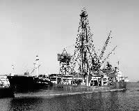 Glomar Challenger |
| Survey Equipment | Survey Info | Data Type(s) | Data Collected |
|---|---|---|---|
| magnetometer | --- | Magnetics | |
| transitsatellite | --- | Navigation | |
| core | --- | Biology Geology | |
| airgun | --- | Air Gun / Water Gun | |
| airgunmonitor | --- | Air Gun / Water Gun | |
| 12khz | --- | Single Beam | |
| bathymetry | --- | Single Beam |
