AKA: none
Other ID: 2010-018-FA
Status: Completed
Organization(s): USGS, Pacific Coastal and Marine Science Center
Funding Program(s): Other (Other)
Principal Investigator(s): Brian Edwards
Affiliate Investigator(s):
Information Specialist(s): Bill Danforth, Brian Edwards
Data Type(s): Imagery: Photo, Imagery: Video, Sampling: Geology, Sonar: Single Beam
Scientific Purpose/Goals: Two-icebreaker US-Canada experiment to identify the outer limits of the extended continental shelf of each nation in the western Arctic Ocean
Vehicle(s): None
Start Port/Location: Dutch Harbor, AK
End Port/Location: Barrow, AK
Start Date: 2010-08-03
End Date: 2010-09-05
Equipment Used: camera, Camera-video, gravitycore, pistoncore, triggercore
Information to be Derived: Bathymetric maps;Sea floor map; Bathymetric maps; Sediment thickness maps
Summary of Activity and Data Gathered: Collected 12 kHz Bathymetry (Simrad EM122) to identify the 2500 meter contour on widely spaced tracklines. Multichannel seismic profiles were collected aboard the Louis St Laurent to map sediment thicknesses.
Staff:
Affiliate Staff:
Notes: Samples reside in Menlo Park.
Location:
Western Arctic Ocean
| Boundaries | |||
|---|---|---|---|
| North: 75.27541261 | South: 51.71822912 | West: -179.824 | East: -127.01171875 |
Platform(s):
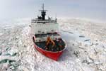 Healy |
| Survey Equipment | Survey Info | Data Type(s) | Data Collected |
|---|---|---|---|
| camera | --- | Photo | |
| Camera-video | --- | Photo Video | |
| gravitycore | --- | Geology | |
| pistoncore | --- | Geology | |
| triggercore | --- | Geology |
