AKA: none
Other ID: Kane_B939009,
Status: Completed
Organization(s): USGS, Pacific Coastal and Marine Science Center
Funding Program(s):
Principal Investigator(s): George Asuncion
Affiliate Investigator(s): Louis Garrison. Robert Fedden
Information Specialist(s):
Data Type(s): Location-Elevation: Navigation, Seismics: Sparker, Sonar: Single Beam, Seismics: Sub Bottom Profiler
Scientific Purpose/Goals: Study of the geophysics, bottom sediments, and hydrography of the Gulf of Mexico.
Vehicle(s):
Start Port/Location: Corpus Christi, TX
End Port/Location: Veracruz, Mexico
Start Date: 1969-02-04
End Date: 1969-02-25
Equipment Used: Sparker, LoranC, sextant, sparker, 3.5khz
Information to be Derived: Sea floor map; Bathymetric maps; Morphology;
Summary of Activity and Data Gathered: Daily Log #5; Geophysics - 160 K seismics.
Staff:
Affiliate Staff:
Notes: Staff from InfoBank:
Louis Garrison Chief Scientist, USGS Corpus Christi
Robert H. Fedden Chief Scientist, NVO
Henry Berryhill Scientist, USGS
Harry Hill Scientist, USGS Western Region
Jack Lee Scientist, USGS Western Region
Mike Marlow Scientist, USGS Western Region
Bob Patrick Scientist, USGS Western Region
Dave Scholl Scientist, USGS Western Region
Dick Tagg Scientist, USGS Western Region
Location:
Gulf of America (Gulf of Mexico)
| Boundaries | |||
|---|---|---|---|
| North: 32.06395559 | South: 17.65970333 | West: -98.9209 | East: -84.296875 |
Platform(s):
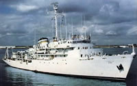 Elisha Kane |
Garrison, L.E., and Martin, R.G., 1973, Geologic structures in the Gulf of Mexico basin: U.S. Geological Survey Professional Paper 773, http://pubs.er.usgs.gov/publication/pp773.
| Survey Equipment | Survey Info | Data Type(s) | Data Collected |
|---|---|---|---|
| Sparker | --- | Sparker | |
| LoranC | --- | Navigation | Integrated navigation (SINS) data (provisional best) |
| sextant | --- | Navigation | |
| sparker | --- | Sparker | microfilm (35 mm microfilm incl. sparker) |
| 3.5khz | --- | Sub Bottom Profiler | analog holdings (singlechannel arcer, fathometer, magnetics, logsheets) |
