AKA: KS73
Other ID: K-1-72-SC
Status: Completed
Organization(s): USGS, Pacific Coastal and Marine Science Center
Funding Program(s):
Principal Investigator(s): Eli A. Silver
Affiliate Investigator(s):
Information Specialist(s):
Data Type(s): Sampling: Geology
Scientific Purpose/Goals:
Vehicle(s):
Start Port/Location:
End Port/Location:
Start Date: 1973-01-01
End Date: 1973-01-01
Equipment Used: dredge
Information to be Derived:
Summary of Activity and Data Gathered: physical holdings listed under K172SC
Staff:
Affiliate Staff:
Notes: Unsure of exact cruise dates, originally listed as 1972 but should be 1973. Samples labeled KS73 or KSB (KSB in map publication).
Staff information imported from InfoBank
Eli Silver (USGS Western Region) - Chief Scientist
Location:
Southern California
| Boundaries | |||
|---|---|---|---|
| North: 34.75 | South: 32.25 | West: -122.75 | East: -116.75 |
Platform(s):
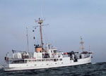 Kelez |
Vedder, J.G., Taylor, J.C., Arnal, R.E., and Bukry, D., 1976, Map showing location of selected pre-Quaternary rock samples from the California continental borderland: U. S. Geological Survey Miscellaneous Field Studies Map 737, https://doi.org/10.3133/mf737.
| Survey Equipment | Survey Info | Data Type(s) | Data Collected |
|---|---|---|---|
| dredge | --- | Geology |
