AKA: KSB, KZ
Other ID: K-1-73-SC
Status: Completed
Organization(s):
Funding Program(s):
Principal Investigator(s): Jack Vedder
Affiliate Investigator(s): Eli Silver
Information Specialist(s):
Data Type(s): Sampling: Geology
Scientific Purpose/Goals:
Vehicle(s):
Start Port/Location:
End Port/Location:
Start Date: 1973-09-07
End Date: 1973-09-08
Equipment Used: dredge
Information to be Derived:
Summary of Activity and Data Gathered: physical data holdings (originally K-1-72-SC)
Staff:
Affiliate Staff:
Notes: FACS ID repurposed for Eli Silver samples collected on the Kelez in 1973.
FACS ID was previously Dave McCulloch's, however no data existed other than dates.
Location:
Southern California
| Boundaries | |||
|---|---|---|---|
| North: 34.75 | South: 32.25 | West: -122.75 | East: -116.75 |
Platform(s):
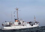 Kelez |
Vedder, J.G., 1990, Maps of California continental borderland showing compositions and ages of bottom samples acquired between 1968 and 1979: U.S. Geological Survey Miscellaneous Field Studies Map 2122, 3 p., https://doi.org/10.3133/mf2122.
Vedder, J.G., Taylor, J.C., Arnal, R.E., and Bukry, D., 1976, Map showing location of selected pre-Quaternary rock samples from the California continental borderland: U. S. Geological Survey Miscellaneous Field Studies Map 737, https://doi.org/10.3133/mf737.
| Survey Equipment | Survey Info | Data Type(s) | Data Collected |
|---|---|---|---|
| dredge | --- | Geology |
