AKA: none
Other ID: L-1-79-SC,Dive_945
Status: Completed
Organization(s):
Funding Program(s):
Principal Investigator(s): Sam Clarke, Gary Greene, Mike Kennedy
Affiliate Investigator(s): Peter Lonsdale (Scripps)
Information Specialist(s):
Data Type(s): Imagery: Photo, Imagery: Video, Location-Elevation: Navigation, Sampling: Biology, Sampling: Geology
Scientific Purpose/Goals: To observe and sample stratigraphic sections displaced along active fault scarps and to evaluate the use of a free deep diving vehicle in studies of offshore faulting.
Vehicle(s):
Start Port/Location:
End Port/Location:
Start Date: 1979-07-27
End Date: 1979-07-30
Equipment Used: gravitycore, radar, transitsatellite, RhoRho, submersible
Information to be Derived:
Summary of Activity and Data Gathered: physical data holdings Five DSRV Alvin dives were made on fault and fault-line scarps associated with the Rose Canyon-Newport-Inglewood, Coronado Bank-Palos Verdes Hills, and San Clemente Fault zones, to investigate the character and recency of faulting of a tectonically active portion of the Southern California Continental Margin. A total of 36 outcrop and 14 sediemnt core samples were collected during the five dives. An effort was made to collect these samples in orderly stratigraphic succession.
Staff: Carol Hirozawa
Affiliate Staff:
Notes: Staff information imported from InfoBank
Sam Clarke (USGS Western Region) - Chief Scientist
Mike Kennedy (CDMG) - Chief Scientist
Gary Greene (USGS Western Region) - Chief Scientist
Peter Lonsdale (Scripps) - Chief Scientist
Carol Hirozawa - USGS Western Region
Location:
Southern California Continental Margin
| Boundaries | |||
|---|---|---|---|
| North: 34.75 | South: 32.25 | West: -122.75 | East: -116.75 |
Platform(s):
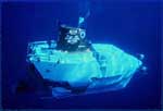 Alvin | 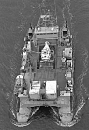 Lulu |
| Survey Equipment | Survey Info | Data Type(s) | Data Collected |
|---|---|---|---|
| gravitycore | --- | Geology | |
| radar | --- | Navigation | |
| transitsatellite | --- | Navigation | |
| RhoRho | --- | Navigation | |
| submersible | --- | Photo Video Biology Geology |
