AKA: M0112PS
Other ID: M112PS, M-1-12-PS, M-01-12-PS
Status: Completed
Organization(s): USGS, Pacific Coastal and Marine Science Center, University of Washington, U.S. Environmental Protection Agency
Funding Program(s): Marine Geomorphology, Evolution, and Habitats (ZP00FE6)
Principal Investigator(s): Guy Cochrane
Affiliate Investigator(s): Bob Pacunski
Information Specialist(s): Guy Cochrane
Data Type(s): Location-Elevation: Navigation, Imagery: Video, Imagery: Photo
Scientific Purpose/Goals: Collect seafloor video data to ground-truth habitat classification of high-resolution bathymetry.
Vehicle(s): None
Start Port/Location: Seattle, WA
End Port/Location: Seattle, WA
Start Date: 2012-08-06
End Date: 2012-08-09
Equipment Used: GPS, underwatercamera, underwater video
Information to be Derived: Subsrate geology and biota
Summary of Activity and Data Gathered: Three days in the S. Salish Sea towing the benthic video sled. Day ops only on the WDFW boat.
Staff: Andrew Ritchie
Affiliate Staff:
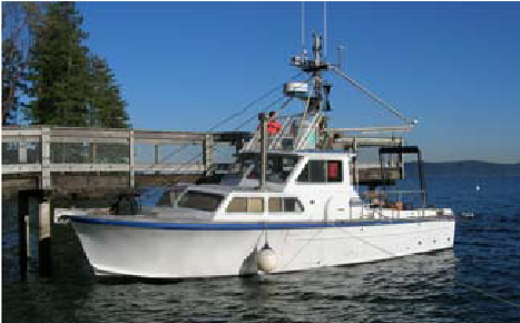
Notes: Vessel is the R/V Molluscan from Washington Department of Fish and Wildlife.
Location:
Southern Salish Sea
| Boundaries | |||
|---|---|---|---|
| North: 47.35 | South: 47.11 | West: -122.77 | East: -122.39 |
Platform(s):
 Molluscan |
Cochrane, G.R., 2022, Bathymetry and topography, video observation, and derived benthic habitat data offshore of Burien, Washington: U.S. Geological Survey data release, https://doi.org/10.5066/P96T1B44.
Cochrane, G.R., 2023, Multibeam echo sounder, video observation, and derived benthic habitat data offshore of Tacoma, Washington: U.S. Geological Survey data release, https://doi.org/10.5066/P9KA6GH2.
| Survey Equipment | Survey Info | Data Type(s) | Data Collected |
|---|---|---|---|
| GPS | --- | Navigation | |
| underwatercamera | --- | Video Photo | |
| underwater video | --- | Video |