AKA: none
Other ID: M-1-02-GM,MW-02-GM
Status: Completed
Organization(s): C&C Technologies, Inc., University of New Brunswick, USGS, Pacific Coastal and Marine Science Center, University of New Hampshire
Funding Program(s): Pacific Seafloor Mapping Project (ZP000LD)
Principal Investigator(s): Jim Gardner
Affiliate Investigator(s):
Information Specialist(s): Peter Dartnell
Data Type(s): Sonar: Multibeam, Location-Elevation: Navigation, Environmental Data: CTD, Sonar: Single Beam, Seismics: Ocean Bottom Seismometer, Sonar: Sidescan
Scientific Purpose/Goals: Map the mid and outer continental shelf region at the head of De Soto Canyon region, northeastern Gulf of America (Gulf of Mexico) to determine the location and extent of deep-water reefs and ridges. It is critical to determine the accurate location, geomorphology, and types of the ridges and reefs to understand the Quaternary history of the area and to assess their importance as benthic habitats for fisheries.
Vehicle(s):
Start Port/Location: Pensacola, Florida
End Port/Location: Pensacola, Florida
Start Date: 2002-06-17
End Date: 2002-07-09
Equipment Used: multibeam, GPS, CTD, bathymetry, navigation, motionsensor, acousticbackscatter
Information to be Derived: Bathymetry and calibrated, co-registered acoustic backscatter
Summary of Activity and Data Gathered: Mapped the head of De Soto Canyon region, northeastern Gulf of America (Gulf of Mexico), collecting multibeam bathymetry and acoustic backscatter. The data will be used to determine the location and extent of deep-water reefs and ridges.
Staff: Larry Mayer
Affiliate Staff:
John Clarke (Univ. of New Brunswick) - Watch Stander
Brian Calder (Univ. of New Hampshire) - Watch Stander
Semme Dijkstra (Univ. of New Hampshire) - Watch Stander
Garreth Elston (Univ. of New Hampshire) - Watch Stander
Yuri Rzhanov (Univ. of New Hampshire) - Watch Stander
James Glynn (Univ. of New Hampshire) - Watch Stander
Chris Glynn (Univ. of New Hampshire) - Watch Stander
Art Kleiner (C&C Technologies
Inc.) - Project Manager
Tim Shannon (C&C Technologies
Inc.) - Field Project Manager
Craig Smith (C&C Technologies
Inc.) - Surveyor
Eric Ortego (C&C Technologies
Inc.) - Surveyor
Brad Daigles (C&C Technologies
Inc.) - Surveyor
Liz Kamp (C&C Technologies
Inc.) - Surveyor
Wes Kitt (C&C Technologies
Inc.) - Surveyor
Al Cousson (C&C Technologies
Inc.) - Surveyor
Sam Alleman (C&C Technologies
Inc.) - Surveyor
Notes: For raw and intermediate data sets, contact Rani Nandiwada
Staff information imported from InfoBank
Jim Gardner (USGS Western Region) - Chief Scientist
John Clarke (Univ. of New Brunswick) - Watch Stander
Larry Mayer (Univ. of New Hampshire) - Watch Stander
Brian Calder (Univ. of New Hampshire) - Watch Stander
Semme Dijkstra (Univ. of New Hampshire) - Watch Stander
Garreth Elston (Univ. of New Hampshire) - Watch Stander
Yuri Rzhanov (Univ. of New Hampshire) - Watch Stander
James Glynn (Univ. of New Hampshire) - Watch Stander
Chris Glynn (Univ. of New Hampshire) - Watch Stander
Art Kleiner (C&C Technologies, Inc.) - Project Manager
Tim Shannon (C&C Technologies, Inc.) - Field Project Manager
Craig Smith (C&C Technologies, Inc.) - Surveyor
Eric Ortego (C&C Technologies, Inc.) - Surveyor
Brad Daigles (C&C Technologies, Inc.) - Surveyor
Liz Kamp (C&C Technologies, Inc.) - Surveyor
Wes Kitt (C&C Technologies, Inc.) - Surveyor
Al Cousson (C&C Technologies, Inc.) - Surveyor
Sam Alleman (C&C Technologies, Inc.) - Surveyor
Location:
Head of De Soto Canyon
| Boundaries | |||
|---|---|---|---|
| North: 30.13334 | South: 29.51666 | West: -87.5667 | East: -86.6 |
Platform(s):
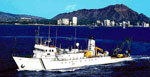 Moana Wave |
Gardner, J.V., John E. Hughes-Clarke, and Larry A. Mayer, 2002, Cruise Report: R/V Moana Wave Cruise M-1-02-GM: Bathymetry and Acoustic Backscatter of the Mid and Outer Continental Shelf, Head of De Soto Canyon, Northeastern Gulf of Mexico: U.S. Geological Survey Open-File Report 02-396, http://pubs.usgs.gov/of/2002/0396/.
| Survey Equipment | Survey Info | Data Type(s) | Data Collected |
|---|---|---|---|
| multibeam | --- | Multibeam | File list |
| GPS | --- | Navigation | |
| CTD | --- | Surveys (geochemical) Experiments (geochemical) CTD | |
| bathymetry | --- | Single Beam | |
| navigation | --- | Navigation | |
| motionsensor | --- | Ocean Bottom Seismometer | |
| acousticbackscatter | --- | Sidescan | File list |
