AKA: none
Other ID: M-1-02-SC
Status: Completed
Organization(s): University of California, Santa Barbara, U.S. Navy, Channel Islands Research Reserve, Naval Post Graduate School, California Department of Fish and Game, USGS, Pacific Coastal and Marine Science Center
Funding Program(s): National Seafloor Mapping and Benthic Habitat Studies (MU195)
Principal Investigator(s): Guy Cochrane
Affiliate Investigator(s): Sarah Fangman (CINMS)
Information Specialist(s):
Data Type(s): Imagery: Video, Location-Elevation: Navigation, Sonar: Sidescan
Scientific Purpose/Goals: Side scan sonar, ROV video surveying, for nearshore benthic habitat mapping. Mapping in North Channel Islands in collaboration with CINMS and US Navy.
Vehicle(s):
Start Port/Location: Port Hueneme
End Port/Location: Port Hueneme
Start Date: 2002-04-28
End Date: 2002-04-30
Equipment Used: Kleinsidescan, YoNav, underwatertelevision
Information to be Derived: Bottom character
Summary of Activity and Data Gathered: Side scan sonar, video surveying
Staff: John Brooks, Greg Cooper, Fred Payne
Affiliate Staff:
Donna Schrueder (UCSB) - Biologist
Mike Prall (CDFG) - GIS specialist
Dave Kuchner (bird watcher
NPS) - Biologist
Jeff Goddard (UCSB) - ROV operator
Jason Tanaka (US Navy) - ROV operator
Vince Gerwe (US Navy) - ROV operator
Shauna Bingham (CINMS) - Public Relations
Julie Bursek (CINMS) - GIS specialist
Ben Waltenberger (CINMS) - GIS specialist
Paul Hillman (Contract photo) - Public Relations
Notes: Associated cruises in southern California: B-1-98-SC B-1-99-SC B-2-99-SC M-1-99-SC M-1-00-SC J-1-02-SC M-1-02-SC M-1-03-SC S-5-04-SC
Staff information imported from InfoBank
Guy Cochrane (USGS) - Chief Scientist
Sarah Fangman (CINMS) - Chief Scientist
Donna Schrueder (UCSB) - Biologist
Mike Prall (CDFG) - GIS specialist
Dave Kuchner (bird watcher, NPS) - Biologist
Jeff Goddard (UCSB) - ROV operator
Fred Payne (USGS) - Sidescan sonar tech
Greg Cooper (US Navy) - ROV operator
Jason Tanaka (US Navy) - ROV operator
Vince Gerwe (US Navy) - ROV operator
Shauna Bingham (CINMS) - Public Relations
Julie Bursek (CINMS) - GIS specialist
Ben Waltenberger (CINMS) - GIS specialist
John Brooks (Contract photo) - Public Relations
Paul Hillman (Contract photo) - Public Relations
Non USGS data manager = Kristin Lee
Location:
Channel Islands
| Boundaries | |||
|---|---|---|---|
| North: 34.17012 | South: 33.84951 | West: -120.4589 | East: -119.20619 |
Platform(s):
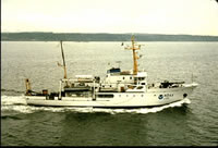 McArthur |
| Survey Equipment | Survey Info | Data Type(s) | Data Collected |
|---|---|---|---|
| Kleinsidescan | --- | Sidescan | Survey information File list |
| YoNav | --- | Navigation | Global positioning system (GPS) data m-1-02-sc.062 (Provisional best file) Global positioning system (GPS) data m-1-02-sc.060 Global positioning system (GPS) data m-1-02-sc.061 Best file with nav in ArcInfo E00 format |
| underwatertelevision | --- | Video |
