AKA: none
Other ID: M-1-04-NC
Status: Completed
Organization(s): Cordell Bank National Marine Sanctuary, Deep Ocean Engineering, Gulf of the Farallones National Marine Sanctuary, National Marine Fisheries Service, Santa Cruz, National Marine Protected Areas Center Science Institute, National Oceanic and Atmospheric Administration, Monterey Bay National Marine Sanctuary, Northwest Fisheries Science Center, USGS, Pacific Coastal and Marine Science Center, Washington State University. Vancouver
Funding Program(s): National Seafloor Mapping and Benthic Habitat Studies (MU195)
Principal Investigator(s): Roberto Anima
Affiliate Investigator(s): Tara Anderson (Ecologist, USGS, NMFS Santa Cruz)
Information Specialist(s): Roberto Anima
Data Type(s): Imagery: Video, Location-Elevation: Navigation, Sonar: Sidescan
Scientific Purpose/Goals: Use side scan sonar and underwater video, to acoustically image, document and film extensive seafloor habitats and life on the seafloor within the MBNMS, CBNMS, and GFNMS as part of a multi-agency seafloor mapping project.
Vehicle(s):
Start Port/Location: Redwood City, CA
End Port/Location: Redwood City, CA
Start Date: 2004-03-31
End Date: 2004-04-22
Equipment Used: underwatertelevision, GPS, Kleinsidescan
Information to be Derived: Side scans; Underwater video; Map of the seafloor in three West Coast national marine sanctuaries: MBNMS, CBNMS, and GFNMS; Groundtruthing of habitat maps in two West Coast national marine sanctuaries using a camera sled (MBNMS and CBNMS); Characterization of habitats and associated benthic macroinvertebrates and fish assemblages in two West Coast national marine sanctuaries using a camera sled (MBNMS and CBNMS).
Summary of Activity and Data Gathered: A variety of seafloor types were identified within the sanctuaryies. For example: 1) Sand-wave habitats were occupied by sanddabs and often contained schools of baby rockfish; 2) Sediment-ripple habitats were commonly occupied by white brittle starts buried within the sediment; 3) Low-lying cobble beds were occupied by encrusting sponges, gorgonians, and half-banded rockfishes; 4) High relief bedrock habitats, although less common on the mid to outer shelf, were occupied by encrusting invertebrates, vase sponges, large anemones, gorgonians, and many species of rockfishes. While the ability to record seafloor descriptions in real time at sea requires a team of dedicated researchers, this approach dramatically improves the speed at which seafloor information can be made available to managers, stakeholders, and the public. Importantly this novel approach also enables web-users to examine the nature of the seafloor at locations of interest with the capability of viewing footage from these areas, within weeks of completion of the survey.
Staff: John Chin, Brian Edwards, John Gann, Larry Kooker, Fred Payne, Andy Stevenson
Affiliate Staff:
Jean de Marignac (Biologist
MBNMS) - Research Leader
Dale Roberts (Biologist
CBNMS) - Research Leader
Erica Burton (Biologist
MBNMS) - Research Leader
Eleyne Phillips (Earth Surface Processes
USGS
Menlo Park) - Research Technician/Biologist
Mark Amend (NMFS Santa Cruz) - Biologist/GIS Specialist
Paul Chetirkin (MBNMS) - Biologist
Julia Clemons (NMFS Newport) - Biologist
Mark Gleason (NMFS Santa Cruz) - Biologist
Dan Howard (Director CBNMS) - Biologist
Chad King (MBNMS) - Biologist/GIS Specialist
Kelly Palacios (MPA) - Biologist/GIS Specialist
Jodi Pirtle (WSU) - Biologist
Sarah Smith (MBNMS) - Biologist
Huff McGonigal (biologist
MBNMS) - Socio
Shane Washburn (DOE) - Camera Engineer
Notes: Associated cruises in northern California: M-1-03-NC M-1-04-NC M-1-05-NC Notes from Cruise Fact Sheet. May 2004. Monterey Bay National Marine Sanctuary SIMoN Program. 17 May 2004 http://www.mbnms-simon.org/docs/build/Fact_sheet_MBNMS_MAC.doc... Multi-agency Seafloor Mapping Project in Monterey Bay, Cordell Bank and Gulf of the Farallones National Marine Sanctuaries National Oceanic and Atmospheric Administration (NOAA) and U.S. Geological Survey (USGS) scientists recently returned from a 21-day research mission with some of the most expansive seafloor documentation ever recorded of the Monterey Bay (MBNMS), Cordell Bank (CBNMS) and Gulf of the Farallones (GFNMS) national marine sanctuaries. The platform for the cruise was the 224 feet NOAA ship McArthur II. This was a collaborative venture involving the MBNMS; CBNMS; GFNMS; USGS; National Marine Fisheries Service (NMFS), Santa Cruz Laboratory; Northwest Fisheries Science Center, Newport, OR; Washington State University Vancouver, Vancouver, WA; NOAA Marine Protected Areas Centers Science Institute (MPA); and Deep Ocean Engineering (DOE). Researchers mapped the seafloor with side-scan sonar and captured video showing the diversity of sea life, health of habitat and characteristics of the seafloor, including a first look at many areas. The cruise consisted of 3 different legs: Cordell Bank Survey (1-7 April); Fanny Shoal and Shelf Survey in GFNMS (7-14 April); and Continental Shelf Survey in the MBNMS (14-22 April). Results of the research from the 2004 McArthur II seafloor mapping cruise of the sanctuaries will provide valuable characterization of sanctuary biology and geology that is useful as a foundation for management of the national marine sanctuaries. Mapping, describing and visualizing seafloor habitats and their biodiversity within the sanctuaries will help managers to protect important habitats, plants, and animals. The knowledge of what is present today will also provide the foundation to monitor changes in these important resources. Goal of mission: To acoustically image, document and film extensive seafloor habitats and life on the seafloor within the MBNMS, CBNMS, and GFNMS as part of a multi-agency seafloor mapping project. Objectives: 1) To map the seafloor in three West Coast national marine sanctuaries: MBNMS, CBNMS, and GFNMS. 2) To groundtruth habitat maps in two West Coast national marine sanctuaries using a camera sled (MBNMS and CBNMS). 3) To characterize habitats and associated benthic macroinvertebrates and fish assemblages in two West Coast national marine sanctuaries using a camera sled (MBNMS and CBNMS). 4) To make mapping information available to the public. Technology and equipment used: The small (125 pounds) video-sled (51 inches long x 16 inches wide x 20 inches high) was towed underwater behind the NOAA research vessel McArthur II to film and document habitats and life over large areas of the seafloor of the MBNMS, CBNMS and GFNMS. Scientists used a Klein 3000 side-scan sonar system to acoustically image several previously unmapped sections of the seafloor within these sanctuaries. During the cruise (April 1 to April 21) teams of scientists worked day and night to collect information on the seafloor using towed video and side-scan sonar. Seafloor descriptions were recorded by the scientists every 30 seconds during real-time observations of the seafloor, providing a wealth of information about habitats and life on the seafloor. Key findings or results: A variety of seafloor types were identified within the sanctuaries: 1) Sand-wave habitats were occupied by sanddabs and often contained schools of baby rockfish. 2) Sediment-ripple habitats were commonly occupied by white brittle stars buried within the sediment. 3) Low-lying cobble beds were occupied by encrusting sponges, gorgonians, and half-banded rockfishes. 4) High relief bedrock habitats, although less common on the mid to outer shelf, were occupied by encrusting invertebrates, vase sponges, large anemones, gorgonians, and many species of rockfishes. While the ability to record seafloor descriptions in real time at sea requires a team of dedicated researchers, this approach dramatically improves the speed at which seafloor information can be made available to managers, stakeholders, and the public. Importantly, this novel approach also enables web-users to examine the nature of the seafloor at locations of interest, with the capability of viewing footage from these areas within weeks of completion of the survey. In addition, close to 300 miles of the seafloor were mapped at Cordell Bank, Fanny Shoal (GFNMS) and off Pescadero Point (MBNMS) using side-scan sonar. Principals: Dr. Tara Anderson, Principal Investigator, Ecologist, USGS Dr. Roberto Anima, Principal Investigator, Geologist, USGS Menlo Park; Dale Roberts, Co-Principal Investigator, Biologist, CBNMS; Jean de Marignac, Co-Principal Investigator and Cruise Co-ordinator (leg 1 and 2), Biologist, MBNMS; John Chin, Co-Principal Investigator, Geologist, USGS Menlo Park. Erica Burton, Cruise Co-ordinator (leg 3), Biologist, MBNMS; This project demonstrates the quantity and quality of work accomplished between government agencies to conduct needed investigative work to ascertain what resources we have in our sanctuaries. The cooperating agencies pulled together sea-floor mapping tools and video-camera expertise to conduct both habitat mapping and biodiversity mapping. Contacts: Dr. Roberto Anima, USGS, (650) 329-5212 Rachel Saunders, MBNMS, (831)647-4237; Andrew DeVogelaere, MBNMS, (831)647-4213; Dan Howard, CBNMS, (415)663-1456. Dr. Tara Anderson, Australia, +61 (7) 4753-4384 On the Web: Sanctuary Integrated Monitoring Program (SIMoN) http://www.mbnms-simon.org/; Monterey Bay National Marine Sanctuary http://montereybay.noaa.gov/; Cordell Bank National Marine Sanctuary http://cordellbank.noaa.gov/; Gulf of the Farallones National Marine Sanctuary http://farallones.noaa.gov/; National Marine Fisheries Services http://santacruz.nmfs.noaa.gov/; U.S. Geological Survey Open-File Report Continental Shelf GIS for the Monterey Bay National Marine Sanctuary http://geopubs.wr.usgs.gov/open-file/of01-179/.
Staff information imported from InfoBank
Tara Anderson (Ecologist, USGS, NMFS Santa Cruz) - Chief Scientist
Roberto Anima (Geologist, USGS Menlo Park) - Chief Scientist
Jean de Marignac (Biologist, MBNMS) - Research Leader
Dale Roberts (Biologist, CBNMS) - Research Leader
Erica Burton (Biologist, MBNMS) - Research Leader
John Chin (USGS Menlo Park) - Geologist
Brian Edwards (USGS Menlo Park) - Geologist
Andy Stevenson (USGS Menlo Park) - Image Processing
Fred Payne (USGS Menlo Park) - Electronics Technician
John Gann (USGS Menlo Park) - Physical Scientist
Larry Kooker (USGS Menlo Park) - Electronics Technician
Eleyne Phillips (Earth Surface Processes, USGS, Menlo Park) - Research Technician/Biologist
Mark Amend (NMFS Santa Cruz) - Biologist/GIS Specialist
Paul Chetirkin (MBNMS) - Biologist
Julia Clemons (NMFS Newport) - Biologist
Mark Gleason (NMFS Santa Cruz) - Biologist
Dan Howard (Director CBNMS) - Biologist
Chad King (MBNMS) - Biologist/GIS Specialist
Kelly Palacios (MPA) - Biologist/GIS Specialist
Jodi Pirtle (WSU) - Biologist
Sarah Smith (MBNMS) - Biologist
Huff McGonigal (biologist, MBNMS) - Socio
Shane Washburn (DOE) - Camera Engineer
Location:
CA
| Boundaries | |||
|---|---|---|---|
| North: 38.2614 | South: 36.85388 | West: -123.458 | East: -121.89277 |
Platform(s):
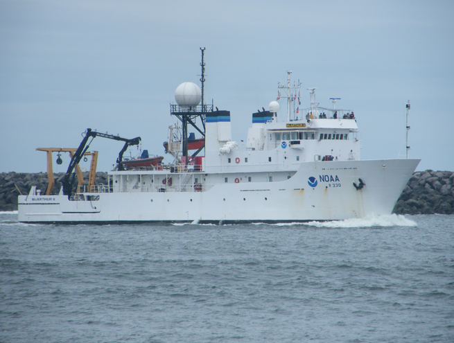 McArthur II |
Anima, R.J., Chin, J.L., Conrad, J.E., and Golden, N.E., 2006, Benthic habitat and geologic mapping of the outer continental shelf of north-central California: U.S. Geological Survey Open-File Report 2006-1177, http://pubs.usgs.gov/of/2006/1177.
| Survey Equipment | Survey Info | Data Type(s) | Data Collected |
|---|---|---|---|
| underwatertelevision | --- | Video | Survey information |
| GPS | --- | Navigation | Global positioning system (GPS) data m-1-04-nc.060 Global positioning system (GPS) data m-1-04-nc.061 (Provisional best file) Global positioning system (GPS) data m-1-04-nc.061_eotcssp Best file with nav in ArcInfo E00 format |
| Kleinsidescan | --- | Sidescan | Survey information File list |
