AKA: none
Other ID: M-1-96-MB
Status: Completed
Organization(s): USGS, Pacific Coastal and Marine Science Center
Funding Program(s): Monterey Bay National Marine Sanctuary (MU182)
Principal Investigator(s): Steve Eittreim, Andy Stevenson
Affiliate Investigator(s):
Information Specialist(s):
Data Type(s): Environmental Data: Current, Location-Elevation: Navigation, Seismics: Boomer, Seismics: Sub Bottom Profiler, Sonar: Sidescan
Scientific Purpose/Goals: Map seafloor geology and shallow subsurface stratigraphy of Monterey Bay Sanctuary continental shelf to better understand the different benthic environments of the Sanctuary; attempt to define vertical profiles of current field in upper 100-m of the water column using acoustic doppler system.
Vehicle(s):
Start Port/Location:
End Port/Location:
Start Date: 1996-05-26
End Date: 1996-06-02
Equipment Used: Kleinsidescan, ADP, GPS, mudseis, mudscan, Geopulse
Information to be Derived: Bottom type (sand, mud, bedrock, bedrock charactistics, active sediment transport indications, biological seep communities or encrustations); Subbottom seismic stratigraphy and structure (stratigraphic style, paleochanneling and terrace formation, fault activity, tectonic uplift or subsidence, geologic history)
Summary of Activity and Data Gathered: Seafloor geologic mapping using sonar side-scan (acoustic backscatter) imagery of the bottom. Shallow subbottom profiling using a 1-kHz sound source which gives information on stratigraphy to depths of about 50 meters. Acoustic backscatter imagery, sub-bottom shallow seismic stratigraphy in SEG-Y format, Acoustic Doppler Current Profiler data.
Staff: Pete Galanis, John Gann, Kaye Kinoshita, Larry Kooker, Marjorie Medrano, Jim Vaughan
Affiliate Staff:
Notes: Physical data holdings
Associated activities: M-1-93-MB J-1-94-MB J-2-95-MB J-6-95-MB M-2-95-MB P-1-95-MB P-3-95-MB R-1-95-MB M-1-96-MB J-1-97-MB J-3-97-MB A-4-98-MB J-3-98-MB J-4-98-MB Interpreted seafloor geologic map of Monterey Bay National Marine Sanctuary continental shelf; Maps of bathymetry and distribution of seismic stratigraphic units; Published studies of past geologic environment of continental shelf. An entry in "Western Region Marine and Coastal Surveys Bulletin", June 7, 1996: MACARTHUR CRUISE Our weather-worn McArthur scientific crew returned to terra firma on Sunday, having completed another 400 square km of mapping on the outer shelf off Santa Cruz and Ano Nuevo. The outer shelf off Ano Nuevo was declared by side-scan sonar watchstanders Galanis, Kinoshita, Medrano, Stevenson, Eittreim, and Lewis to be perhaps the most boring piece of seafloor on the face of the earth, with the possible exception of the deep Bering Sea. Now that it is done, at least well never have to return again. Moderately high winds kept the lively ship McArthur true to her reputation, although extraordinary skill in line planning kept her moving either dead down-wind, or upwind, keeping the rolls to a minimum. 400-m line spacing with the Klein 100 kHz side-scan and 1-kHz Geopulse high-resolution gives us a nearly complete and dense coverage of the continental shelf of Monterey Bay proper. Last minute snafus in scheduling nearly resulted in abandonment of the cruise, but our Marine Facility folks pulled it out of the fire for us with some extraordinarily creative and flexible manpower deployments, including Gann and Kooker onboard as technical brainpower. Thanks to NOAAs PR savvy, the cruise was heavy with lots of outreachy stuff: press conferences onboard on May 28 and June 2, resulting in several TV news program scoops and articles in the SC Sentinel (front page), the Monterey Herald, and other newspapers.
Staff information imported from InfoBank
Steve Eittriem (USGS Western Region) - Chief Scientist
Andy Stevenson (USGS Western Region) - Chief Scientist
Larry Kooker (USGS Western Region) - Electronics Technician
John Gann (USGS Western Region) - Electronics Technician
Kaye Kinoshita (USGS Western Region) - Watchstander
Jim Vaughan (USGS Western Region) - Watchstander
Marjorie Medrano (USGS Western Region) - Watchstander
Pete Galanis (USGS Western Region) - Watchstander
Location:
California
| Boundaries | |||
|---|---|---|---|
| North: 37.21393 | South: 36.80203 | West: -122.717 | East: -121.8537 |
Platform(s):
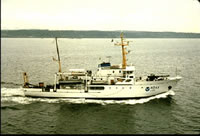 McArthur |
Eittreim, S.L., and Noble, M., 2002, Seafloor geology and natural environment of the Monterey Bay National Marine Sanctuary: Marine Geology, v. 181 no. 1-3, pp. 1–2, doi: 10.1016/S0025-3227(01)00258-4.
Wong, F., and Eittreim, S., 2001, Continental Shelf GIS for the Monterey Bay National Marine Sanctuary: U.S. Geological Survey Open-File Report 01-179, http://pubs.usgs.gov/of/2001/0179/.
| Survey Equipment | Survey Info | Data Type(s) | Data Collected |
|---|---|---|---|
| Kleinsidescan | --- | Sidescan | sidescan (data on FAD) File list |
| ADP | --- | Current | |
| GPS | --- | Navigation | Best file with nav in ArcInfo E00 format Global positioning system (GPS) data m-1-96-mb.060 (Provisional best file) Lines Global positioning system (GPS) data m-1-96-mb.060_degree |
| mudseis | --- | Sub Bottom Profiler | |
| mudscan | --- | Sidescan | |
| Geopulse | --- | Boomer |
