AKA: none
Other ID: M-1-97-WO,AR-5-97
Status: Completed
Organization(s): USGS, Pacific Coastal and Marine Science Center
Funding Program(s): Coastal Change Hazards (MU051), Crustal Earthquake Hazards (MU077), Southwest Washington Coastal Erosion Study (MU274)
Principal Investigator(s): Pat McCrory
Affiliate Investigator(s): Dave Twichell
Information Specialist(s): Michael Hamer
Data Type(s): Location-Elevation: Navigation, Sampling: Geology, Seismics: Boomer, Seismics: Sub Bottom Profiler, Sonar: Sidescan
Scientific Purpose/Goals: Collect geophysical data to aid in characterizing seismic hazard of nearshore faults & coastal erosion hazard
Vehicle(s):
Start Port/Location:
End Port/Location:
Start Date: 1997-07-07
End Date: 1997-07-15
Equipment Used: GPS, 3.5khz, Geopulse, Shipekgrab, boomer, sidescansonar
Information to be Derived: Seafloor character, late quaternary sediment thickness, shallow (
Summary of Activity and Data Gathered: Collect approx 400 km of high resolution seismic reflection and sidescan sonar data
Staff: David Foster, Scott Harrison
Affiliate Staff:
Tom O'Brien (USGS Woods Hole) - Electronics Technician
Jim Morris (NOAA) - Ship Captain
Notes:
Staff information imported from InfoBank
Pat McCrory (USGS Western Region) - Chief Scientist
Dave Foster (USGS Western Region) - Computer Analyst
Scott Harrison (USGS Western Region) - Computer Analyst
Tom O'Brien (USGS Woods Hole) - Electronics Technician
Jim Morris (NOAA) - Ship Captain
Location:
Southwest Washington Inner Shelf
| Boundaries | |||
|---|---|---|---|
| North: 48.32233 | South: 46.91283 | West: -125.9447 | East: -124.22401 |
Platform(s):
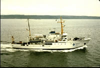 McArthur |
Schreppel, H.A., Degnan, C.H, Dadisman, S.V., and Metzger, D.R., 2013, Archive of U.S. Geological Survey Selected Single-Beam Bathymetry Datasets, 1969â2000: U.S. Geological Survey Data Series 757, http://pubs.usgs.gov/ds/757/.
| Survey Equipment | Survey Info | Data Type(s) | Data Collected |
|---|---|---|---|
| GPS | --- | Navigation | Best file with nav in ArcInfo E00 format Integrated navigation (SINS) data m-1-97-wo.051 Global positioning system (GPS) data m-1-97-wo.061 (Provisional best file) Lines Global positioning system (GPS) data m-1-97-wo.061_degree |
| 3.5khz | --- | Sub Bottom Profiler | NGDC MGD77 data - bathy Raw depth (bathymetry) data m-1-97-wo.300 Raw depth (bathymetry) data m-1-97-wo.300_061 (Provisional best file) |
| Geopulse | --- | Boomer | Raw seismic shot point data m-1-97-wo.400 Raw seismic shot point data m-1-97-wo.400_071 Seismic FFID/Shot/CDP data m-1-97-wo.410_061 |
| Shipekgrab | --- | Geology | Station Information |
| boomer | --- | Boomer | |
| sidescansonar | --- | Sidescan |
