AKA: none
Other ID: P-04-11-CC
Status: Completed
Organization(s): Pacific Gas and Electric Company
Funding Program(s):
Data Source Information:
Information Specialist(s): Jonathan Childs
Data Type(s): Location-Elevation: Navigation, Seismics: Multichannel
Start Date: 2011-12-06
End Date: 2012-10-05
Equipment Used: navigation, Multichannel
Information to be Derived:
Summary of Activity and Data Gathered:
Notes: MCS Data transferred from PG&E to USGS for posting on NAMSS. Limited information available.
Location:
San Luis Bay
| Boundaries | |||
|---|---|---|---|
| North: 38.75 | South: 34.75 | West: -124.75 | East: -114.25 |
Platform(s):
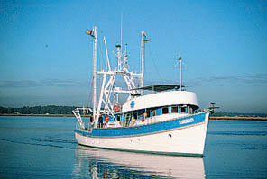
 M/V Bluefin |
Kluesner, J.W., Brothers, D.S., and Sliter, R.W., 2017, Reprocessed 3D seismic-reflection data and neural-network fault cube of field activity P-04-11-CC, offshore Point Sal, central California, 2012-08-12 to 2012-10-05: U.S. Geological Survey data release.
Kluesner, J.W., Brothers, D.S., and Sliter, R.W., 2017, Reprocessed 3D seismic-reflection data and neural-network fault cube of field activity P-04-11-CC, offshore Point Sal, central California, 2012-08-12 to 2012-10-05: U.S. Geological Survey data release.
Kluesner, J.W., Brothers, D.S., and Sliter, R.W., 2017, Reprocessed boomer 3D seismic-reflection data of field activity P-04-11-CC in Estero Bay, offshore of Morro Bay, central California, 2012-08-12 to 2012-10-05: U.S. Geological Survey data release.
Kluesner, J.W., Brothers, D.S., and Sliter, R.W., 2017, Reprocessed boomer 3D seismic-reflection data of field activity P-04-11-CC, in San Luis Obispo Bay, offshore of Pismo Beach, central California, 2011-12-06 to 2012-10-05: U.S. Geological Survey data release.
| Survey Equipment | Survey Info | Data Type(s) | Data Collected |
|---|---|---|---|
| navigation | --- | Navigation | |
| Multichannel | --- | Multichannel | Reprocessed 3D seismic-reflection data and neural-network fault cube, offshore of Point Sal, central California, from 2012-08-12 to 2012-10-05 (This dataset includes reprocessed boomer 3D seismic data collected by the Fugro Consultants Inc. in 2012, offshore Point Sal, central California.) Reprocessed boomer 3D seismic-reflection data collected in San Luis Obispo Bay, offshore of Pismo Beach, central California, from 2011-12-06 to 2012-10-05 (This dataset includes reprocessed boomer 3D seismic data collected by the Fugro Consultants Inc. in 2012, in San Luis Obispo Bay, offshore of Pismo Beach, central California.) Reprocessed boomer 3D seismic-reflection data collected in Estero Bay, offshore of Morro Bay, central California, from 2012-08-12 to 2012-10-05 (This dataset includes reprocessed boomer 3D seismic data collected by the Fugro Consultants Inc. in 2012, in Estero Bay, offshore of Morro Bay, central California.) |