AKA: none
Other ID: P-1-72-SC,GAVIOTA
Status: Completed
Organization(s): USGS, Pacific Coastal and Marine Science Center
Funding Program(s): Pt. Conception (MU234)
Principal Investigator(s): Dave McCulloch, Steve Wolf
Affiliate Investigator(s):
Information Specialist(s): Steve Wolf
Data Type(s): Location-Elevation: Navigation, Seismics: Air Gun / Water Gun, Seismics: Boomer, Sonar: Single Beam
Scientific Purpose/Goals: Geophysical investigations of the Santa Monica basin, southern California.
Vehicle(s):
Start Port/Location:
End Port/Location:
Start Date: 1972-02-28
End Date: 1972-03-24
Equipment Used: navigation, bathymetry, arcer, uniboom
Information to be Derived: Seismic reflection profiles, bathymetry.
Summary of Activity and Data Gathered: Seismic reflection and bathymetry study from Cape San Martin to Santa Rosa Island, Southern California. 11 rolls of bathymetry, 53 rolls of uniboom, and 48 rolls of arcer records.
Staff: Bob Graf, Frank Lewis, Jim Nicholson, Bill Olander, Lowell Scott
Affiliate Staff:
Notes: Staff information imported from InfoBank
Dave McCulloch (USGS Western Region) - Chief Scientist
Steve Wolf (USGS Western Region) - Chief Scientist
Frank Lewis (USGS Western Region) - Crew
Bob Graf (USGS Western Region) - Crew
Jim Nicholson (USGS Western Region) - Crew
Lowell Scott (USGS Western Region) - Crew
Bill Olander (USGS Western Region) - Crew
Location:
Southern California
| Boundaries | |||
|---|---|---|---|
| North: 34.75 | South: 32.25 | West: -122.75 | East: -116.75 |
Platform(s):
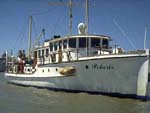 Polaris I |
Wolf, S.C., 1975, Seismic reflection profiles: R/V Polaris March 1972, offshore Southern California, Pt. Conception cruise: U.S. Geological Survey Open-File Report 75-166.
| Survey Equipment | Survey Info | Data Type(s) | Data Collected |
|---|---|---|---|
| navigation | --- | Navigation | |
| bathymetry | --- | Single Beam | |
| arcer | --- | Air Gun / Water Gun | |
| uniboom | --- | Boomer |
