AKA: none
Other ID: P-1-92-AR
Status: Completed
Organization(s):
Funding Program(s):
Principal Investigator(s): Art Grantz
Affiliate Investigator(s):
Information Specialist(s):
Data Type(s): Electro-Magnetic: Gravity, Electro-Magnetic: Magnetics, Environmental Data: CTD, Location-Elevation: Navigation, Sampling: Biology, Sampling: Chemistry, Sampling: Geology, Seismics: Air Gun / Water Gun, Seismics: Multichannel, Seismics: Sonobuoy, Seismics: Sub Bottom Profiler
Scientific Purpose/Goals:
Vehicle(s):
Start Port/Location:
End Port/Location:
Start Date: 1992-08-21
End Date: 1992-09-24
Equipment Used: Other, multichannel, 3.5khz, magnetics, sonobuoy, pistoncore, boxcore, CTD, dartcore, gravitycore, Niskenbottle, gravity, navigation, airgun
Information to be Derived:
Summary of Activity and Data Gathered:
Staff: Peter Barnes, Kevin Foley, Eric Funk, Patrick Hart, Dave Hogg, Steve May, Michael McCormick, Mark McLaughlin, Mike Mullen, Walt Olson, Kevin O'Toole, Larry Phillips, Ledabeth Pickthorn, Erk Reimnitz, Ransom Rideout, Bill Robinson
Affiliate Staff:
Jens Bischof (U of Wis) - Geologist
Alan Gagnon (WHOI) - Mechanical Technician
Nick Hardigg (Earthvisn) - Photographer
Martin Jeffries (U of AK) - Geophysicist
Shusun Li (U of Ak) - Geologist
Niels Norgaard (Geologist) - Pedersen
Kenneth Schwartz (U of AK) - Geophysicist
Ron Perkin (IOS
BC) - Oceanographer
Paul Hagstrum (USCG) - Ship Captain
David Visniski (USCG) - Chief Engineer
Notes: physical data holdings
seismic equipment type added 2/14/18
Staff information imported from InfoBank
Art Grantz (USGS Western Region) - Chief Scientist
Peter Barnes (USGS Western Region) - Geologist
Jens Bischof (U of Wis) - Geologist
Kevin Foley (USGS Western Region, Reston) - Geologist
Alan Gagnon (WHOI) - Mechanical Technician
Ledabeth Pickthorn (USGS Western Region, listed as Gray) - Navigator
Nick Hardigg (Earthvisn) - Photographer
Pat Hart (USGS Western Region) - Geophysicist
Dave Hogg (USGS Western Region) - Electronics Technician
Martin Jeffries (U of AK) - Geophysicist
Shusun Li (U of Ak) - Geologist
Steven May (USGS Western Region) - Geophysicist
Michael McCormick (USGS Western Region) - Geologist
Mark McLaughlin (USGS Western Region) - Geologist
Mike Mullen - Geologist
Niels Norgaard (Geologist) - Pedersen
Walt Olson (USGS Western Region) - Mechanical Technician
Kevin O'Toole (USGS Western Region) - Mechanical Technician
Larry Phillips (USGS Western Region) - Geologist
Erk Reimnitz (USGS Western Region) - Geologist
Ransom Rideout (USGS Western Region) - Mechanical Technician
Bill Robinson (USGS Western Region) - Electrical Engineer
Kenneth Schwartz (U of AK) - Geophysicist
Ron Perkin (IOS, BC) - Oceanographer
Paul Hagstrum (USCG) - Ship Captain
Eric Funk (USCG) - Chief Mate
David Visniski (USCG) - Chief Engineer
Location:
Chukchi Continental Borderland
| Boundaries | |||
|---|---|---|---|
| North: 76.38012 | South: 71.30992 | West: -164.845 | East: -153.90829 |
Platform(s):
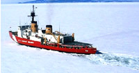 Polar Star |
Grantz, A., Barnes, P.W., Gray, L.B., Hart, P.E., Hogg, D.J., May, S.D., McCormick, M., McLaughlin, M.W., Mullen, M.W., Phillips, R.L., Olson, W.P., Jr., O'Toole, J.K., Reimnitz, E., Rideout, R.W., Jr., Robinson, W.C., Foley, K.M., Bischof, J., Gagnon, A.R., Jeffries, M.O., Li, S., Schwartz, K., Norgaard-Pedersen, N., and Perkin, R., 1993, Cruise to the Chukchi Borderland, Arctic Ocean: American Geophysical Union Eos, Transactions, v. 74 no. 22, pp. 249–254, doi: 10.1029/93EO00273.
