AKA: none
Other ID: P-1-94-AR,AOS
Status: Completed
Organization(s):
Funding Program(s): Global Change, Arctic Tectonics (MU123)
Principal Investigator(s): Art Grantz
Affiliate Investigator(s):
Information Specialist(s):
Data Type(s): Location-Elevation: Navigation, Sampling: Biology, Sampling: Geology, Sonar: Single Beam
Scientific Purpose/Goals: Climatic history of the western Arctic Ocean basin; Origin of the Amerasia Basin, Arctic Ocean, and its continental margins. Paleoclimate of Amerasia Basin, Arctic Ocean; geologic framework, Arctic Basin
Vehicle(s):
Start Port/Location:
End Port/Location:
Start Date: 1994-07-25
End Date: 1994-08-30
Equipment Used: boxcore, navigation, pistoncore, bathymetry
Information to be Derived:
Summary of Activity and Data Gathered: Collected 18 box cores; 16 piston cores; 17 bulk sediment samples were collected from ice flows; 7 bulk sediment samples were collected for radionuclide testing; 3 wood samples were collected; 38 samples were filtered to determine suspended particulate matter concentration (29 were ice core samples, 6 were snow samples, 3 were water samples)
Staff: Patrick Hart, Steve May, Mike Mullen, Walt Olson, Kevin O'Toole, Fred Payne, Larry Phillips, Erk Reimnitz, Bob Robinson
Affiliate Staff:
Notes: physical data holdings
(From 8/12/94 USGS Bulletin) August 10,1994. Art Grantz sends the following progress report: We are working north near 82d N, 175d E doing mainly biologic studies of the water column, benthic biology, sea ice studies, and air and upper water column chemistry. The geologic program has been collecting the required global change piston and box cores, but no seismic data to date. At least two of our piston cores are about 28 ft. long, but none have reached bedrock. Erk Reimnitz is having a field day on and in the ice. Sea ice conditions were moderate early on, but fairly difficult now. However, satellite imagery suggests that ice conditions are somewhat easier to the northwest, over Wrangell Abyssal Plain, where we are now headed. We will try to concentrate our seismic and coring program on prime geologic targets between 85d N and the Pole and 150d and 175d W. Worked from Point Barrow to the North Pole. Two ships are involved, the U.S. Coast Guard ship Polar Sea and Canadian Coast Guard ice-breaker Louis S. St. Laurent. Geologic sampling and seismic reflection studies were conducted in the55-day expedition across 3,700 miles of Arctic Ocean. Some cores came up bubbling so they were sealed in pressure vessels to test whether they might contain gas hydrate. AOS (Arctic Ocean Section)
Staff information imported from InfoBank
Art Grantz (USGS Western Region) - Chief Scientist
Pat Hart (USGS Western Region) - Geophysicist
Mike Mullen (USGS Western Region) - Geologist
Walt Olson (USGS Western Region) - Technician
Kevin O'Toole (USGS Western Region) - Technician
Larry Phillips (USGS Western Region) - Scientist
Fred Payne (USGS Western Region) - Electronics Technician
Erk Reimnitz (USGS Western Region) - Scientist
Bob Robinson (USGS Western Region) - Unspecified
Steve May (USGS Western Region) - Scientist
Location:
Arctic Ocean
| Boundaries | |||
|---|---|---|---|
| North: 77.09351562 | South: 67.09351562 | West: -170.8594 | East: -132.03125 |
Platform(s):
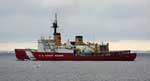 Polar Sea |
Grantz, A., Clark, D.L., Phillips, R.L., and Srivastava, S.P., 1998, Phanerozoic stratigraphy of Northwind Ridge, magnetic anomalies in the Canada basin, and the geometry and timing of rifting in the Amerasia basin, Artic Ocean: GSA Bulletin, v. 110 no. 6, pp. 801–820, doi: http://dx.doi.org/10.1130/0016-7606(1998)110%3C0801:PSONRM%3E2.3.CO;2.
Schreppel, H.A., Degnan, C.H, Dadisman, S.V., and Metzger, D.R., 2013, Archive of U.S. Geological Survey Selected Single-Beam Bathymetry Datasets, 1969â2000: U.S. Geological Survey Data Series 757, http://pubs.usgs.gov/ds/757/.
| Survey Equipment | Survey Info | Data Type(s) | Data Collected |
|---|---|---|---|
| boxcore | --- | Biology Geology | Station Information box core logs (data in holdings) |
| navigation | --- | Navigation | Integrated navigation (SINS) data p-1-94-ar.050_degree Integrated navigation (SINS) data p-1-94-ar.050 (Provisional best file) Best file with nav in ArcInfo E00 format |
| pistoncore | --- | Geology | Station Information piston core logs (data in holdings) |
| bathymetry | --- | Single Beam | NGDC MGD77 data - bathy Raw depth (bathymetry) data p-1-94-ar.302 Raw depth (bathymetry) data p-1-94-ar.300 Raw depth (bathymetry) data p-1-94-ar.302_050 (Provisional best file) |
