AKA: none
Other ID: R-1-88-AN
Status: Completed
Organization(s): Texas A&M University, Technical University of Denmark, Scripps Institution Of Oceanography, La Jolla, Ca, USGS, Pacific Coastal and Marine Science Center
Funding Program(s):
Principal Investigator(s): John Barron
Affiliate Investigator(s): Birger Larsen (Technical University Of Denmark),Jack Baldauf (Texas A&M University)
Information Specialist(s): Alan Cooper
Data Type(s): Electro-Magnetic: Magnetics, Location-Elevation: Navigation, Seismics: Sub Bottom Profiler, Sonar: Single Beam
Scientific Purpose/Goals: Bathymetric and seismic reflection investigation.
Vehicle(s):
Start Port/Location: PYRDZ BAY, ANTARCTICA
End Port/Location: FREEMANTLE, AUSTRALIA
Start Date: 1988-01-04
End Date: 1988-02-20
Equipment Used: 12khz, navigation, 3.5khz, magnetometer, seismic
Information to be Derived: Bathymetric and seismic reflection profiles.
Summary of Activity and Data Gathered: 6568 miles of seismic data.
Staff:
Affiliate Staff:
Notes: Scripps Institution of Oceanography, ODP leg 119. See also R187AN for first half of this cruise
Staff information imported from InfoBank
John Barron (USGS Western Region) - Chief Scientist
Birger Larsen (Technical University Of Denmark) - Chief Scientist
Jack Baldauf (Texas A&M University) - Chief Scientist
Location:
Antarctica
| Boundaries | |||
|---|---|---|---|
| North: -33.96316 | South: -68.77556 | West: 73.0212 | East: 113.69983 |
Platform(s):
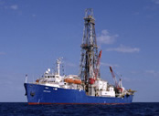 Joides Resolution |
Kvenvolden, K.A., Hostettler, Frances D., Rapp, John B., and Frank, Tamara J., 1990, Aliphatic hydrocarbons in sediments from Prydz Bay, Antarctica, in Stewart, Sondra, ed., Proceedings of the Ocean Drilling Program, Peru continental margin; covering Leg 112 of the cruises of the Drilling Vessel JOIDES Resolution, Callao, Peru to Valparaiso, Chile, sites 679-688, 20 October 1986-25 December 1986: Proceedings of the Ocean Drilling Program, Scientific Results 112, pp. 417–424.
