AKA: none
Other ID: S-2-07-SC
Status: Completed
Organization(s): USGS, Pacific Coastal and Marine Science Center
Funding Program(s): National Seafloor Mapping and Benthic Habitat Studies (MU195)
Principal Investigator(s): Guy Cochrane
Affiliate Investigator(s):
Information Specialist(s): Guy Cochrane
Data Type(s): Imagery: Photo, Location-Elevation: Navigation, Seismics: Sub Bottom Profiler, Sonar: Sound Velocity
Scientific Purpose/Goals: Seafloor mapping using SEASwath sonar and video groundtruthing to characterize substrate type in the nearshore waters southwest of Santa Rosa Island in the Channel Islands National Marine Sanctuary
Vehicle(s):
Start Port/Location: Santa Barbara Harbor
End Port/Location: Santa Barbara Harbor
Start Date: 2007-08-06
End Date: 2007-08-18
Equipment Used: Submetrix, underwatercamera, GPS, soundvelocityprofiler
Information to be Derived: Bathymetry, acoustic backscatter, water-bottom video
Summary of Activity and Data Gathered:
Staff: Michael Boyle, David Finlayson, Gerry Hatcher
Affiliate Staff:
Eleyne Phillips (USGS) - GIS Specialist
Donna Schroeder (UCSB) - Biologist
Notes: files on /imgarc2/S-2-07-SC
Staff information imported from InfoBank
Guy Cochrane (USGS) - Chief Scientist
Mike Boyle (USGS) - Electronics Technician
Gerry Hatcher (USGS) - Electronics Technician
David Finlayson (USGS) - Sonar Technician
Eleyne Phillips (USGS) - GIS Specialist
Donna Schroeder (UCSB) - Biologist
Non USGS data manager = Eleyne Phillips
Location:
Southern California
| Boundaries | |||
|---|---|---|---|
| North: 34.40902 | South: 33.88458 | West: -120.354 | East: -119.2629 |
Platform(s):
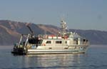 Shearwater |
Cochrane, G.R., Finlayson, D.P., and Dailey, E.T., 2018, Bathymetry and acoustic backscatter data collected in 2007 from the San Miguel Passage in the Channel Islands, California: U.S. Geological Survey data release, https://doi.org/10.5066/F78G8HVC.
| Survey Equipment | Survey Info | Data Type(s) | Data Collected |
|---|---|---|---|
| Submetrix | --- | Sub Bottom Profiler | File list |
| underwatercamera | --- | Video Photo | |
| GPS | --- | Navigation | Best file with nav in ArcInfo E00 format Global positioning system (GPS) data s-2-07-sc.061 (Provisional best file) |
| soundvelocityprofiler | --- | Sound Velocity | Acoustic backscatter data collected in 2007 from the San Miguel Passage in the Channel Islands, California (This portion of the data release presents acoustic backscatter data from the San Miguel Passage, in the Channel Islands, California. The data were collected in August 2007 by the U.S. Geological Survey, Pacific Coastal and Marine Science Center (USGS, PCMSC) using a 234.5 kHz SEA (AP) Ltd. SWATHplus-M phase-differencing sidescan sonar mounted on the NOAA, Channel Islands National Marine Sanctuary R/V Shearwater as part of the research cruise S-2-07-SC. Data were collected in water depths up to 89 meters. The San Miguel Passage is within the Channel Islands National Marine Sanctuary and is the body of water between the two western-most islands of the chain - Santa Rosa and San Miguel Islands. The data were processed at the USGS, PCMSC to create a 2-meter resolution TIFF raster, presented here.) Bathymetry data collected in 2007 from the San Miguel Passage in the Channel Islands, California (This portion of the data release presents bathymetry data from the San Miguel Passage, in the Channel Islands, California. Bathymetry data were collected in the San Miguel Passage, Channel Islands, California in August 2007 by the U.S. Geological Survey, Pacific Coastal and Marine Science Center (USGS, PCMSC). Collection was accomplished using a 234.5 kHz SEA (AP) Ltd. SWATHplus-M phase-differencing sidescan sonar mounted on the NOAA, Channel Islands National Marine Sanctuary R/V Shearwater as part of the USGS research cruise S-2-07-SC. Data were collected in water depths up to 89 meters. The San Miguel Passage is within the Channel Islands National Marine Sanctuary and is the body of water between the two western-most islands of the chain - Santa Rosa and San Miguel Islands. The data were processed at the USGS, PCMSC to create a 2-meter resolution TIFF raster, presented here.) |
