AKA: none
Other ID: T-1-69-VI
Status: Completed
Organization(s): U.S. Navy, General Electric Company, National Aeronautics and Space Administration, USGS, Pacific Coastal and Marine Science Center
Funding Program(s): Tektite I (MU283)
Principal Investigator(s):
Affiliate Investigator(s):
Information Specialist(s):
Data Type(s): Visual Identification: Submersible Observations
Scientific Purpose/Goals: Map the underwater reefs and topography, sea level changes, underwater oil deposits, sedimentation dynamics of the ocean floor, growth rate of algae, migration patterns and growth rates of plankton, reef habitat, movements and behaviors.
Vehicle(s):
Start Port/Location: N/A
End Port/Location: N/A
Start Date: 1969-02-15
End Date: 1969-04-15
Equipment Used: scuba
Information to be Derived: Map of underwater reefs, bathymetry, sea-level change data, biohabitat
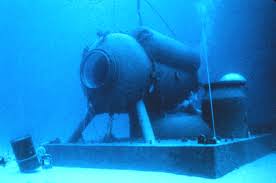
Summary of Activity and Data Gathered: Worked for 58 days at 50 ft depth. Compilation of a detailed map that delineated bottom-sediment types over the area within swimming range (about 1000 ft) of the habitat. Studied rates of reworking on organisms on sand flats adjacent to coral reefs in the vicinity of the habitat and found that the upper layer of sediment is completely reworked in only a few days. Artificially constructed ridges comparable to sand ripples were obliterated by organisms within a week. Studies also showed that empty pelecypod valves in the low-energy reef environment generally lie concave side upward, a distinctly different orientation than that formed by wave and current activity along a high-energy coast; such differences may be useful for identifying ancient depositional environments.
Staff: Ed Clifton
Affiliate Staff:
Richard Waller (U.S. Bureau of Commercial Fisheries) - Oceanographer
Conrad Mahnken (U.S. Bureau of Commercial Fisheries) - Oceanographer
John VanDerwalker (U.S. Bureau of Commercial Fisheries) - Marine Biologist
Notes:
Staff information imported from InfoBank
Ed Clifton (USGS Western Region) - Geologist
Richard Waller (U.S. Bureau of Commercial Fisheries) - Oceanographer
Conrad Mahnken (U.S. Bureau of Commercial Fisheries) - Oceanographer
John VanDerwalker (U.S. Bureau of Commercial Fisheries) - Marine Biologist
Location:
Virgin Island
| Boundaries | |||
|---|---|---|---|
| North: 19 | South: 17 | West: -66 | East: -63 |
Platform(s):
 Tektite |
| Survey Equipment | Survey Info | Data Type(s) | Data Collected |
|---|---|---|---|
| scuba | --- | Submersible Observations |
