AKA: none
Other ID: U-2-71-GM,71002
Status: Completed
Organization(s): USGS, Corpus Christi, TX
Funding Program(s): International Decade of Ocean Exploration (IDOE) (MU151)
Principal Investigator(s): Jack Vedder
Affiliate Investigator(s):
Information Specialist(s):
Data Type(s): Electro-Magnetic: Gravity, Electro-Magnetic: Magnetics, Location-Elevation: Navigation, Seismics: Sonobuoy, Sonar: Single Beam
Scientific Purpose/Goals: Scientific objectives of Leg 2 were: 1) to investigate the evolution of the continental margin east of the Yucatan Peninsula and its relation to concepts of continental margin development: 2) to explore the possibility of structural and stratigraphic links between western Cuba and the Yucatan Peninsula; 3) to study the western terminus of the Cayman Ridge and Trench system and to determine its influence on the structure of British Honduras and Guatemala; 4) to examine the Yucatan Basin in order to interpret the origin of this distinct sea floor feature in the northwestern Caribbean; 5) to learn more about the nature of interaction between the North American and Caribbean plates in this area.
Vehicle(s):
Start Port/Location:
End Port/Location:
Start Date: 1971-06-23
End Date: 1971-07-08
Equipment Used: gravity, magnetics, navigation, bathymetry
Information to be Derived:
Summary of Activity and Data Gathered: physical data holdings
Staff: Bill Dillon
Affiliate Staff:
A.E. Roberts - Geologist
B.D. Ruppel - Geophysicist
A.G. HcHendrie - Geologist
P.E. Malin - Geophysicist
C.A. Rodeick - Phys. Sci Tech
H.R. Hill - Electronic Tech
R.A. Patrick - Electronic Tech
Notes: NSF/IDOE, From USGS Eastern Region admincru database... Control # --- 843 PlatformDate ID --- UGEO19710619 Sea Days --- 25 Scientists --- 12 Scientific Days --- 300 WHFC Persons --- 9 WHFC Person Days --- 225 Study Region... Northern East Coast --- N Middle East Coast --- N Southern East Coast --- N Puerto Rico --- Y Gulf Coast --- N Virgin Islands --- Y
Staff information imported from InfoBank
Jack Vedder (USGS Western Region) - Chief Scientist
Bill Dillon - Geologist
A.E. Roberts - Geologist
B.D. Ruppel - Geophysicist
A.G. HcHendrie - Geologist
P.E. Malin - Geophysicist
C.A. Rodeick - Phys. Sci Tech
H.R. Hill - Electronic Tech
R.A. Patrick - Electronic Tech
Location:
East Margin Yucatan Peninsula
| Boundaries | |||
|---|---|---|---|
| North: 20.73333 | South: 16.5883 | West: -87.9652 | East: -83.74833 |
Platform(s):
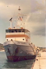 United Geo I |
Dillon, W.P., Vedder, J.G., and Graf, R.J., 1972, Structural profile of the northwestern Caribbean: Earth and Planetary Science Letters, v. 17 no. 1, pp. 175–180, URL: https://doi.org/10.1016/0012-821X(72)90273-7.
USGS, 1973, Journal of Research of the U. S. Geological Survey, 1973, volume 1, issue 2: Reston, VA.
Vedder, J.G., 1972, Acoustic reflection profiles, East Margin, Yucatan Peninsula: Leg 2, 1971 cruise, UNITEDGEO I: U. S. Geological Survey Unnumbered Series, 15 p., https://doi.org/10.3133/70121102.
Vedder, J.G., MacLeod, N.S., Lanphere, M.A., and Dillon, W.P., 1973, Age and tectonic implications of some low-grade metamorphic rocks from the Yucatan Channel: Journal of Research of the U.S. Geological Survey, v. 1 no. 2, pp. 157–164, URL: https://pubs.er.usgs.gov/publication/70160642.
| Survey Equipment | Survey Info | Data Type(s) | Data Collected |
|---|---|---|---|
| gravity | --- | Gravity | Free Air Anomaly data u-2-71-gm.160 Free Air Anomaly data u-2-71-gm.160_050 (Provisional best file) |
| magnetics | --- | Magnetics | Raw magnetics data u-2-71-gm.200 Raw magnetics data u-2-71-gm.200_050 Edited magnetics data u-2-71-gm.220_050 (Provisional best file) |
| navigation | --- | Navigation | Integrated navigation (SINS) data u-2-71-gm.050_degree Best file with nav in ArcInfo E00 format Integrated navigation (SINS) data u-2-71-gm.050 (Provisional best file) |
| bathymetry | --- | Single Beam | Edited bathymetry data with corrected depths u-2-71-gm.325 Edited bathymetry data with corrected depths u-2-71-gm.325_050 (Provisional best file) |
