AKA: none
Other ID: V-1-80-NC
Status: Completed
Organization(s): USGS, Pacific Coastal and Marine Science Center
Funding Program(s):
Principal Investigator(s): Jim Gardner, Dave Klise
Affiliate Investigator(s):
Information Specialist(s):
Data Type(s): Location-Elevation: Navigation, Sampling: Chemistry, Sampling: Geology, Seismics: Sub Bottom Profiler, Time Series: Mooring (physical oceanography)
Scientific Purpose/Goals: To identify the present-day dispersal and accumulation of Russian River sediment on the adjacent margin.
Vehicle(s):
Start Port/Location: Redwood City, CA
End Port/Location: Redwood City, CA
Start Date: 1980-09-18
End Date: 1980-09-23
Equipment Used: miniranger, pistoncore, gravitycore, Niskenbottle, 3.5khz, instrumentmooring, LoranC
Information to be Derived: Bathymetry, grain size, radiographs, sediment analysis, clay mineralogy, pollen data, carbon data, carbonate data, geochemical data, diatom, radiolarian, nannofossils, foraminifera.
Summary of Activity and Data Gathered: physical data holdings
Staff: Roger Anderson, Neal Barnes, Jim Barry, Bob Hall, Kevin O'Toole, John Saladin, Rex Sanders, Mark Yeats
Affiliate Staff:
Andre Valots - Ship Captain
Joseph Williamson - Chief Engineer
Susan Mathews - Navigator
William Nunes - Chief Mate
Notes: Staff information imported from InfoBank
Andre Valots - Ship Captain
Dave Klise (USGS Western Region) - Chief Scientist
Jim Barry (USGS Western Region) - Geologist
Jim Gardner (USGS Western Region) - Chief Scientist
John Saladin (USGS Western Region) - Electronics Technician
Joseph Williamson - Chief Engineer
Kevin O'Toole (USGS Western Region) - Mechanical Technician
Mark Yeats (USGS Western Region) - Geologist
Neal Barnes (USGS Western Region) - Geologist
Rex Sanders (USGS Western Region) - Navigator
Bob Hall (USGS Western Region) - Geologist
Roger Anderson (USGS Western Region) - Geologist
Susan Mathews - Navigator
William Nunes - Chief Mate
Non USGS data manager = Susan Mathews
Location:
Northern California
| Boundaries | |||
|---|---|---|---|
| North: 38.51583 | South: 38.28283 | West: -124.0833 | East: -123.02917 |
Platform(s):
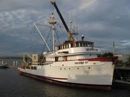
 Velero |
Klise, D.H., 1984, Modern sedimentation on the California Continental Margin adjacent to the Russian River, San Jose, CA: San Jose State University Master of Science Thesis, 120 p.
Reid, J.A., Reid, J.M., Jenkins, C.J., Zimmermann, M., Williams, S.J., and Field, M.E., 2006, usSEABED: Pacific coast (California, Oregon, Washington) offshore surficial-sediment data release: U.S. Geological Survey Data Series 182, http://pubs.usgs.gov/ds/2006/182/.
| Survey Equipment | Survey Info | Data Type(s) | Data Collected |
|---|---|---|---|
| miniranger | --- | Navigation | Lines Metadata Best file with nav in ArcInfo E00 format Integrated navigation (SINS) data v-1-80-nc.052 (Provisional best file) |
| pistoncore | --- | Geology | Station Information foram slides (data in holdings) |
| gravitycore | --- | Geology | Station Information |
| Niskenbottle | --- | Chemistry | Station Information |
| 3.5khz | --- | Sub Bottom Profiler | Metadata |
| instrumentmooring | --- | Geology Mooring (physical oceanography) | Metadata |
| LoranC | --- | Navigation |