AKA: none
Other ID: W-1-82-NC,CODE_2-1
Status: Completed
Organization(s):
Funding Program(s):
Principal Investigator(s): Dave Cacchione
Affiliate Investigator(s): Wendell Brown (OSU), Wendall Brown
Information Specialist(s):
Data Type(s): Sonar: Sidescan, Environmental Data: CTD, Sampling: Biology, Sampling: Geology, Time Series: Mooring (physical oceanography), Sampling: Chemistry, Environmental Data: Wave, Location-Elevation: Navigation
Scientific Purpose/Goals:
Vehicle(s):
Start Port/Location: Yerba Buena Island, CA
End Port/Location: Yerba Buena Island, CA
Start Date: 1982-03-03
End Date: 1982-03-08
Equipment Used: sidescansonar, CTD, boxcore, Geoprobe, Niskenbottle, wavepressure, rangerange, LoranC
Information to be Derived:
Summary of Activity and Data Gathered:
Staff: Dave Drake, George Tate, Jack Swenson, Jim Nicholson, Mike Korso, Monty Hampton, Joanne Thede
Affiliate Staff:
Ann Dorkins (OSU) - Watchstander
Beth Laband - Watchstander
Ed Lacoursier (URI) - Mechanical Technician
Jeff List (USGS Woods Hole) - Watchstander
Pat O'Malley (WHOI) - Mechanical Technician
Steve Lentz (URI) - Watchstander
Notes:
Staff information imported from InfoBank
Dave Cacchione (USGS Western Region) - Chief Scientist
Ann Dorkins (OSU) - Watchstander
Beth Laband - Watchstander
Dave Drake (USGS Western Region) - Geologist
Ed Lacoursier (URI) - Mechanical Technician
George Tate (USGS Western Region) - Geologist
Jack Swenson - Electronics Technician
Jeff List (USGS Woods Hole) - Watchstander
Jim Nicholson (USGS Western Region) - Electronics Technician
Joanne Ferreira (USGS Western Region) - Geologist
Mike Korso (USGS Western Region) - Watchstander
Monty Hampton (USGS Western Region) - Geologist
Pat O'Malley (WHOI) - Mechanical Technician
Steve Lentz (URI) - Watchstander
Wendell Brown (OSU) - Chief Scientist
Location:
Northern California
| Boundaries | |||
|---|---|---|---|
| North: 38.82667 | South: 38.5666 | West: -123.7317 | East: -123.46167 |
Platform(s):
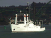 Wecoma |
Reid, J.A., Reid, J.M., Jenkins, C.J., Zimmermann, M., Williams, S.J., and Field, M.E., 2006, usSEABED: Pacific coast (California, Oregon, Washington) offshore surficial-sediment data release: U.S. Geological Survey Data Series 182, http://pubs.usgs.gov/ds/2006/182/.
| Survey Equipment | Survey Info | Data Type(s) | Data Collected |
|---|---|---|---|
| sidescansonar | --- | Sidescan | |
| CTD | --- | Surveys (geochemical) Experiments (geochemical) CTD | Station Information |
| boxcore | --- | Chemistry Biology Geology | Station Information |
| Geoprobe | --- | Mooring (physical oceanography) | Station Information |
| Niskenbottle | --- | Chemistry | |
| wavepressure | --- | Wave | Station Information |
| rangerange | --- | Navigation | |
| LoranC | --- | Navigation | Lines Best file with nav in ArcInfo E00 format Global positioning system (GPS) data w-1-82-nc.060 (Provisional best file) |
