AKA: none
Other ID: W-1-95-NC
Status: Completed
Organization(s):
Funding Program(s): Strata Formations on Margins (Strataform) (MU278)
Principal Investigator(s): John Barber, Peter Dartnell, Dave Drake
Affiliate Investigator(s):
Information Specialist(s):
Data Type(s): Sampling: Biology, Sampling: Geology
Scientific Purpose/Goals: The STRATAFORM project is looking into understanding (i.e., modelling) margin stratigraphy on time scales from individual storm events to units representing 10s of thousands of years.
Vehicle(s):
Start Port/Location:
End Port/Location:
Start Date: 1995-02-08
End Date: 1995-02-18
Equipment Used: boxcore
Information to be Derived:
Summary of Activity and Data Gathered: Heavy January rains on the west coast led to record river and sediment discharges. From 8 February to 18 February, John Barber, Pete Dartnell and Dave Drake took our NEL box corer and joined the "Rapid Response Sampling Team" of the ONR-funded STRATAFORM project aboard the R/V WECOMA of Oregon State University for a box coring binge on the shelf off the Russian and Eel Rivers. A dozen scientists, students and technicians managed to hammer out about 90 box cores of the 1995 flood sediment on those shelves. The Eel shelf proved to be a bonanza with reddish-tan flood sediment forming a layer up to 10 cm thick on the mid-shelf. Many of the benthic organisms had been covered so rapidly that they had apparently suffocated.
Staff:
Affiliate Staff:
Notes: 1995 WEST COAST FLOOD DEPOSITS: This field effort was a first step in a multiyear project which involves Mike Field, Jim Gardner, Homa Lee, Dave Cacchione and Dave Drake from USGS as well as a host of scientists from universities, industry and the Navy.
Staff information imported from InfoBank
John Barber (USGS Western Region) - Chief Scientist
Pete Dartnell (USGS Western Region) - Chief Scientist
Dave Drake (USGS Western Region) - Chief Scientist
Location:
California
| Boundaries | |||
|---|---|---|---|
| North: 41.75 | South: 37.75 | West: -125.75 | East: -122.25 |
Platform(s):
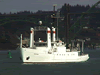 Wecoma |
| Survey Equipment | Survey Info | Data Type(s) | Data Collected |
|---|---|---|---|
| boxcore | --- | Biology Geology |
