
USGS Coastal and Marine Hazards and Resources Program
Digital Shoreline Analysis System (DSAS) version 2.0
An ArcView© extension for calculating shoreline change.
U. S. Geological Survey Open-File Report 03-076
by E. Robert Thieler, Daniel Martin, and Ayhan Ergul
2003
If you use the DSAS extension, please cite the following publication:
Thieler, E. R., Martin, D., and Ergul, A., 2003. The Digital Shoreline
Analysis System, version 2.0: Shoreline change measurement software
extension for ArcView. USGS Open-File Report 03-076.
The current version is 2.2.1 * Please use the current DSAS for ArcGIS available here. The following files are available for download: Readme_dsas.txt -
README file with installation instructions, known issues, and
version history For more information, contact: |
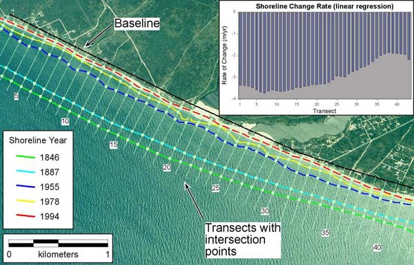
The Digital Shoreline Analysis System (DSAS) version 2.2.1 extends the normal functionality of the ArcView© version 3.2 (and later) geographic information system to include historic shoreline change analysis. The DSAS 2.2.1 was developed by the USGS in cooperation with TPMC. The application extension is designed to efficiently lead a user through the major steps of shoreline change analysis in a clearly organized and attractive user interface. This extension to ArcView contains three main components to assist a user to define a baseline, generate orthogonal transects at a user defined separation along the coast and to calculate rates of change (linear regression, endpoint rate, average of rates, average of endpoints, jackknife). The extension utilizes Avenue code to develop transects and rates and uses the Avenue programming environment to automate and customize the user interface. If you would like to receive announcements of DSAS updates via e-mail, please contact Rob Thieler (rthieler#64;usgs.gov). The DSAS 2.2.1 does not run under ArcView/ArcGIS. Please refer to the DSAS 3.0 release for the current/supported version of this software. 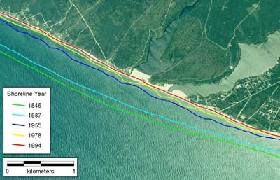 Historic shorelines for a portion of southwestern Nantucket Island, Massachusetts. |
Historic shorelines and DSAS-generated transects at 100 meter spacing with histogram showing rates of shoreline change computed using simple linear regression. |
This report is preliminary and has not been reviewed for conformity with U.S. Geological Survey editorial standards (or with the North American Stratigraphic Code).
Any use of trade, product, or firm names is for descriptive purposes only and does not imply endorsement by the U.S. government.
These pages are provisional and contain computer software or scripts that may be
changed without notice as new versions or revisions of the material are created.
Although this program has been used by the USGS, no warranty, expressed or
implied, is made by the USGS or the United States Government as to the accuracy
and functioning of the program and related program material nor shall the fact of
distribution constitute any such warranty, and no responsibility is assumed by the
USGS in connection therewith.